Search This Blog (A.K.A. "I Dote On...")

Showing posts with label urbanism. Show all posts

Tuesday, March 16, 2010

Urban St. Louis v2.0

The Urban St. Louis forums (http://urbanstl.com/forum/), usually referred to simply as "UrbanSTL", have spent the past couple months undergoing a series of changes. The site has long been St. Louis's go-to source for urban-related news and developments. To those of us who have enjoyed the website since the mid 2000s, the UrbanSTL of those shaky few months was a shadow of its former self. As the forum regularly crashed or froze up, users dwindled and posts became more infrequent.


The new interface

What was once a good source for finding out just about any built environment news, new developments, or other issues in St. Louis became a wholly frustrating experience.

Thankfully, some creative (and patient!) minds have gotten together and retooled the site, adding several new features. Most importantly, the new UrbanSTL is fast and reliable. May its network and frequent posters repopulate so that St. Louis can again brag of this more-than-useful resource!

What I am calling Urban St. Louis v2.0 is integrated with Alex Ihnen's St. Louis Urban Workshop blog, meaning that UrbanSTL now has a companion/host website to aggregate news and developments. Furthermore, the site contains a "social" section to connect with other forumers and a wiki so that users can avoid wading through 400 pages of rumors and chatter about Ballpark Village and find only the latest news.

I encourage every reader of this blog to register and contribute to the discussion. For those who have sworn the site off due to its past problems, rejoice and reconcile!

UrbanSTL is (or at least was) a truly thriving online community unique to St. Louis. Even larger and more prosperous Boston, with its ArchBoston forum, once expressed envy over St. Louis's urbanism forum. Let's make that the case once more! Click here to visit the forum directly.

Wednesday, February 17, 2010

Form-Based Zoning Coming to (Part of) St. Louis

In the 1920s, the town of Euclid, Ohio set up a rudimentary zoning code that drew the ire of some well-off local landowners. These individuals believed the city's attempt to restrict the use of their land constituted a "taking" and, moreover, was unconstitutional. The resulting landmark Euclid v. Ambler Realty Co. Supreme Court case would, surprisingly, declare zoning not only constitutional, but necessary.

This is where the name "Euclidian" zoning arises. Euclidian zoning entails neat separation of land uses. "Mixed-use" properties, combining residential, office, and retail perhaps, would not be allowed under a strict Euclidian zoning code.

Most planners today realize the utility of zoning but lament the modernist interpretation of zoning represented by the Euclidian manner. Corner stores, live-work units, even clean industry surrounding housing--all have gained acceptance as essential parts of a varied, diverse urban fabric. Recently, urban planners have been looking for a way to regulate land that does not stifle the way cities were meant to work.

Enter Form-Based Zoning.

Rather than merely regulate the uses of structures, form-based zoning looks at the appropriateness of scale, design, height, etc. to the urban environment. It's a relatively new concept, pioneered by New Urbanists like Andres Duany, and has been applied in a few cities now (Petaluma, California was one of the first).

Now, St. Louis may be jumping in on the game.

Central West End Midtown Development is nearly finished with its form-based zoning code for its service area--the southern portion of the Central West End and parts of Midtown. Read more at the Washington University Medical Center Redevelopment Corp.'s blog.

Some nuggets from that blog post:

The proposal will be implemented in three phases:
1. The Building Envelope Standards (to regulate the physical form of the area)
2. General Design Standards (to preserve and create the appropriate urban experience)
3. Sustainable Building Standards (to incentivise various levels of green development)

Here is an excerpt from the Building Envelope plan (click to enlarge):


I think this is a wonderful effort for the Central West End, Midtown, and St. Louis. I will be eager to see more of the details, such as how design is to be regulated, but this seems like a good start.

If I had one major criticism, it would be, of course, the parking. Requiring one off-street parking space per residential unit seems a little high for a truly urban neighborhood like the Central West End. It might make more sense to make one space the maximum allowed parking rather than the minimum. I am also wondering what strategy neighborhood residents chose to pursue: the modified existing envelope or the contextual envelope. The former would have allowed for more high-intensity development, especially on Lindell, Forest Park, and Vandeventer. The latter would be more cautious and preservation-minded, keeping almost all historic structures and preserving the scale of neighborhoods as they are today.

The form-based code should certainly block, say, a CVS from tearing down a group of buildings for a suburban store with a drive-through (which, of course, almost happened). It should also not allow for the rebuilding of McDonalds and Arby's in their usual forms, which already did happen.

This code should be strong and urban, solidifying the Central West End/Midtown as St. Louis's most urban experience. I am definitely eager to see the final product.

Tuesday, December 15, 2009

Random Thoughts on the Cult of Destruction in St. Louis

In anticipation of a temporary move to Baltimore (more on that later), I was using Google Streetview to surf the city—extensively so.

After an hour or so of clicking and zooming and dropping the yellow Streetview man all over the city, several emotions came over me: shock, admiration, depression, and hope. 

Shock, primarily, because I cannot believe how intact the city of Baltimore is. I found a fairly large area on the northern periphery of downtown that seemed to have been cleared and replaced with a series of modern housing developments. Yet, for the most part, Baltimore’s signature (and unrelenting) row houses are e-v-e-r-y-w-h-e-r-e. The density and population capacity the city must have had at its height are simply astounding! Even knowing something of Baltimore’s history and architectural vernacular, I was still caught off guard. This was where the admiration came in; at the power of cities working at their best to produce a better quality of life simply by being cities. By being walkable. By having services located nearby. By offering opportunities for a tight-knit community to form. While Baltimore’s rows seem more monotonous than, say, St. Louis’s more architecturally diverse vintage 1880s streetscapes, even they offer a level of democratic individuality.

(I know I’m romanticizing a lot, but keep in mind I’m speaking of cities at their utmost ideal; the fulfillment of their potential).

The depression took me upon seeing whole blocks of these rows boarded, vacant. No cars, no trees, no pedestrians lining the streets. Just walls of row houses sitting vacant. I could “hear” the eerie silence even behind the computer screen, hundreds and hundreds of miles away. I got to thinking: how has Baltimore not torn out more of these rows and created park space or built new housing or just left them fallow, waiting for a time when investment would bring something new? Do whole abandoned blocks not cause issues with surrounding occupied blocks? Do they not pull the image of the city down? This, mind you, was my gut reaction, even as an avowed preservationist. Of course, I was happy to see them remain—thus the hope that later kicked in—but even I was wondering how they could have been spared the wrecking ball.

Then I remembered that I’m a St. Louisan; an automatic member of the cult of destruction. 

My leaders have, time and time again, supported the removal of a sturdy built environment and its replacement with something much less, something much worse. Often the replacement is meant to serve the purpose of moving or storing automobiles. This is the city’s greatest power because it is the simplest task at its disposal. Vacant buildings and lots provide convenient opportunities for combining narrow urban lots to form parking lots and garages. A 1920s-era bond issue already widened most roads to an extent likely even then excessive; certainly this was so by the time the region’s vast interstate network was introduced. So a declined city that wants to better move automobiles through itself need only maintain its roads and ensure every new development has ample parking.

The more and more I experience cities, the less and less I am willing to accept St. Louis's exceptional status as a destroyer of its most unique asset, its built environment.

Check out this recent thread on Skyscraper Page, but especially this 1950s-era photo of a recently-constructed Pruitt-Igoe complex at Jefferson and Cass:


You might see where this is going: I’m going to rail on the brand of urban renewal represented by Pruitt-Igoe. It’s out of scale, tore down a dozen blocks in the making, and apparently was not very well-built to serve the population it intended to serve. Sure.
 
But look around! Pruitt-Igoe’s decline certainly had a strong influence on its surroundings, but no one at the St. Louis Housing Authority held a gun to the city’s head and demanded they do this to the surrounding neighborhoods!  Of the hundreds and hundreds of structures shown in the photo, nearly all have been demolished, including the 33 11-story Pruitt-Igoe towers themselves.

Look to the south of the site (bottom and bottom-left in the photo). We see, in order, Cole, Carr, then Easton, today’s Martin Luther King Jr. Blvd. Row after row of cast iron storefronts—gone, no matter how irreplaceable they might have been! Look to the west (far left in the photo), today’s Jeff Vanderlou with apparently beautiful rows of mid- to late-19th Century houses, shops, and churches.

North (top and top right of the photo) shows the portion of St. Louis Place that’s now an “urban prairie”. This site was already tattered when plans circulated in the early 1990s to place a golf course and gated community on the site. Of course, since there was a plan, even an unfunded and ill-conceived one, the buildings came down. Now, naturally, Paul McKee, Jr., of the North Side development, is picking and choosing which of these structures represent “salvageable” “legacy properties”. In other words, we can reasonably expect yet more clearance of a good number of properties in this photo that have clung to life over decades of turbulent change.


New Orleans has endured decades of decline, like St. Louis, and, recently, one of the nation's worst natural disasters ever recorded, unlike St. Louis. It is said that 33 percent of New Orleans' structures are officially "blighted" circa 2009. Certainly blight in either city is formidable and a problem that needs to be addressed sensitively. The answer, however, is not to simply tear out buildings right as they become vacant. No New Orleans neighborhood--not even the most-storm damaged--is as empty as St. Louis Place. New Orleans did replace old neighborhoods with a series of low-rise public housing complexes, but their surroundings did not become the urban blank slates witnessed in St. Louis.


We must look to our peer cities and realize that our history and heritage, but moreover our urban built environment are our greatest assets. We need a comprehensive plan, backed by the force of law, to protect our remaining assets and to encourage the growth of new ones bound for their own protection oneday. We need to make sure we no longer take lightly the piecemeal (or wholesale) destruction of our built environment for something less or worse than what was there.


We need to recognize that our autocentric infrastructure not only destroyed neighborhoods upon its introduction. Our interstates and oversize roads continue to provide barriers to pedestrians and still lower adjacent property values and, of course, are still ugly and disrespectful of their urban context.


We need to be bold and comprehensive with regard to stabilizing and strengthening our built environment. Planners and designers of Pruitt-Igoe had the wrong idea--the superblock, the identical hulking towers, the clearance projects--but they had the optimism, the sense of direction, and the boldness and comprehensiveness nailed. Today's stock of leaders in our city are diffident, conservative, fearful or unwilling to change anything for the better.


We need new zoning and urban design guidelines to ensure that neighborhoods such as those pictured surrounding the Pruitt-Igoe complex can repopulate and spawn a new, bold identity. While Paul McKee has apparently stepped up to the plate to do so, this blog has communicated before its lack of faith in the city to assure something bold and truly beneficial to the area, aesthetically or socially speaking.


So when I use this blog to harp on a business needlessly taking down two buildings for outdoor dining, or a gas station in Hyde Park demolishing a vacant but beautiful historic commercial row for expansion, or yet another church ruthlessly ripping out mixed use buildings for a parking lot...I'm thinking of the photograph above. If only we had pro-urban rather than anti-urban planning! None of this would happen. There would not need to be so many individual battles; prospective parking lot pavers would encounter difficulties, roadblocks in making our city less walkable, less enjoyable, more ugly, less human. The photograph shows we have suffered too much, too long, too deeply.


We can solidify St. Louis as an urban environment. We must!


Wednesday, October 28, 2009

The St. Louis Mile: Longer Than 5,280 Feet?

There are several factors in what makes a place walkable.

Citing my own mix of experience in studying Jane Jacobs and urbanism, as well as being a pretty well-travelled pedestrian in both St. Louis and New Orleans, I would list the following on my "walkability" check list:
  • Manageable building heights, with any towers stepped back from the "base". Personally, for both walking and living, I prefer roomier and quainter residential districts and neighborhood-scale commercial areas to mid- and high-rise districts anyway.
  • The street should either be narrow enough to slow traffic, or have traffic slow enough to make me feel safe crossing right after a yellow light.
  • Of course, street trees serve multiple purposes for pedestrians: beautification, shade, rain barriers, buffer from cars, etc.
  • Seeing other people walking or having other visual interest and activity around makes walking less monotonous.
  • Building designs, from block to block, are hopefully varied and interesting as much as the activity on the street.

But the most important point is that there be a lot of corners. As a friend of mine here in New Orleans noted, corners are the lifeblood of urbanism. A plurality of them means more opportunities for neighborhood commerce and exchange, whether that's said in the literal sense (retail, restaurant, etc.) or the sense of community, wherein people "run into" one another and strike up conversations upon turning a corner.

Street corners force automobiles and other traffic to be more vigilant, especially the more of them there are and the more automobiles clamoring to get on one of the main roads. Almost no matter what, corners display the visual complexity of urban life. The best moment as a pedestrian (especially a leisurely pedestrian not in a time crunch) is to happen upon a busy corner and to be literally drawn in each direction to the point of having to halt in the middle of the sidewalk to decide if that corner over there merits a jaunt just to check things out.

In St. Louis, I think automatically to:


View Larger Map

Or perhaps less obviously:


View Larger Map

Either way, my "explorer" alarm goes off when I see such interesting things on all four corners (bonus points go to traffic circles that form super-intersections that remain pedestrian-friendly).


The reality is that St. Louis doesn't meet all of my requirements for full pedestrian comfort just yet. That's all right, as many areas are slowly getting there (Forest Park Southeast, Tower Grove South along Morgan Ford, etc.). Yet one problem with St. Louis's corner-making potential is that the blocks that feed into the mixed-use districts tend to be too long. In nearly all areas outside of St. Louis's old Creole street grid (Soulard, Old North, and Downtown), we have long "Victorian" blocks that were laid out with the notion of keeping activity (whether that activity is through pedestrians, streetcars, or vehicles) on shorter main roads with more corners.


To return to Maryland and Euclid in the Central West End:


The green line (North Euclid between Maryland and Pershing) is 477 feet.
The red line (Pershing Place between Kingshighway and Euclid) is 855 feet.


You'll notice that the "walkable" block (north-south) is Euclid, while the residential streets are nearly double the length and therefore less walkable. That means I have to amble twice as far to find the activity and vibrancy than if I were walking down Euclid (throw on top of this argument the fact that private or closed-off streets make a lot of pedestrians feel uncomfortable and unwelcome). Cherokee's situation is reversed in directionality, but is the same for all practical purposes. North-south streets are long, while intersecting east-west blocks with more commercial uses are short. It seems ingenious, and does contribute to walkable "strips" of activity.


But my contention is not that Cherokee, or Euclid, are not walkable streets. I feel that the city as a whole has committed the number one sin of walkability: making distances seem farther than they really are.


I've noted on this blog before the issue with long blocks (Jane Jacobs is not a fan, either). For drivers and for pedestrians, they offer fewer routes to get to the same place, thereby concentrating activity on the main drags. This is great for the driver of a vehicle who wants to, say, park on the northern end of Euclid (say, Delmar), get out of a car, and walk the strip down to Maryland Avenue. But for those who live technically within a sensible American walkable range (1/2 mile), their options for getting to Euclid and Maryland are probably insufficiently diverse as to ensure they walk every time if they still own a car. It doesn't help that it's often not very difficult to find a parking spot anywhere in St. Louis. That's a separate (albeit related) issue that I hear a lot of urbanists comment upon. I hear less about the perception of distance in St. Louis, which may be more related to long blocks than we think. A study is definitely needed.


To wit: when friends from St. Louis visit New Orleans, I usually forewarn them that when I say we're walking to a place that's "only 12 blocks away", it means we're roughly "six St. Louis blocks" from our destination. The number sounds scary to the inexperienced pedestrian, but the constant interest of the intersecting streets and their corners (not to mention the activity and the nearly universal human scale architecture) ease the pain a lot. For St. Louis, I fear a mile seems much beyond the traditional 5,280 feet metric in pedestrian psychology.


Maybe one reason folks don't talk about the problem of long blocks in St. Louis is that, well, it's an intractable one. Few people these days would argue we need to tear down houses in Tower Grove Heights to create new corners and through-ways (I wouldn't!). And pedestrian pathways, while nice features on overly long blocks, usually suffer from a look of privacy and, (as in the Northampton neighborhood's walk ways) and do not create corners in the traditional sense.


We could look to this interesting case out of the suburbs of New Orleans for some of our more tattered neighborhoods: the "Goodbee Square" in Covington, Louisiana. In this system, a grid is staggered to make north-south travel (in this case) inefficient for vehicles. While the article goes on to suggest that pedestrian paths should be created for such a system to make walking easier, a slight modification of such a grid could produce logical pedestrian paths, more corners, and at the same time make sure the new roads aren't used as cut-throughs exclusively. See below:


For intact neighborhoods, it's a matter of getting more people walking and returning corner mixed-use properties back to commercial life. Even if the grid itself can't be altered, a return to widespread commercial properties will still lend each block with a solid corner a degree of urban excitement, randomness, and possibility of discovery that St. Louis so needs.


It's a matter of public art, whether on sidewalks, in varied tree plantings, on the streets, fire hydrants, in gardens, even streetlights...St. Louis needs much more unexpected bursts of color and life.


Some neighborhoods, such as Forest Park Southeast, Downtown, and Old North, have various forms of themed walking trails. These are delineated by signs and markers. They make the unsuspecting pedestrian passer-by curious and might spawn further exploration. In other neighborhoods, removing concrete barriers and allowing vehicular traffic back through will strip these streets of their "semi-private" status and encourage more walkers. And I'm always an advocate of re-styling or removing altogether certain members of our much too intrusive interstate system, which creates wide psychological gaps as well (how far apart do Shaw and old McRee Town seem to you?).


The best way to reduce the St. Louis mile, if you're interested, is to walk anyway. Active streets are interesting streets. But it wouldn't hurt for you to create that interesting sidewalk art. Or plant that garden. Or plan the walking trail. Or lobby to patch up our tattered street grid. By then, hopefully walking will be so pleasant we won't even be thinking about how many more steps and blocks it is to that ultimate destination.

Tuesday, September 22, 2009

Forest Park's Biggest Flaw - Now Never to Be Corrected?

Often called the "jewel" of St. Louis (certainly of its park system), Forest Park is a difficult space to critique in its entirety. With its variety of attractions, cultural institutions, beautiful vistas, running and biking paths, golf courses, and more, it definitely causes a moment of pause to reflect: thank the heavens the County-secessionists kept this 1,200 acre wonderment within city limits upon drawing the boundaries in 1876.

(Okay, I could complain a bit here. Other large municipal parks have cut down on paved roads and turned the park into more of an urban, pedestrian-friendly destination. And, as St. Louis Urban Workshop notes on his blog, Forest Park could definitely feature more spaces in which to simply hang out and people watch.)

To me, the biggest flaw of Forest Park is a somewhat disappointing connection to nearby neighborhoods. On each side, there's an issue.

On the west (Skinker Boulevard), you have an overly wide road that does carry a high volume of traffic. It's noisy, difficult to cross during the day, and somewhat uninviting, though a tree canopy helps a bit. Regardless, this edge of the park appears the most active and therefore enticing. It's no doubt bolstered by the presence of Washington University at its doorstep and all of its students/faculty.

On the north (Lindell), there are beautiful, stately homes, but I have never seen much activity flow out of these single-family manses. I always wonder if this portion of Lindell had developed as Pershing (formerly Berling) did, with all of its mid-rises, what Forest Park's northern edge might be like. It would have been wonderful to be able to sit at a sidewalk cafe patio and stare into the park, urbanely surrounded by an attractive turn-of-the-century skyline. Don't get me wrong, the present homes are splendid; my feelings toward them are not exactly ambivalent. I just wonder how they could be employed to make Forest Park's northern edge even better. I'm excited by the possibility of the proposed Delmar Loop Streetcar continuing eastward from DeBaliviere on Lindell and into the Central West End. In New Orleans, the St. Charles Avenue streetcar carts tourists and locals alike who, cameras in hand, enjoy gawking at inconceivable wealth and their historic mansions. Could St. Louis have its own version of this pleasant, tourist-friendly transit ride? I think so.


A St. Charles Avenue streetcar passes in front of one of the many mansions on the famous street. Source.


The east side of Forest Park (Kingshighway) is an interesting case. Just to the northeast sits one of St. Louis's mostly densely-walked neighborhoods and just to the east is the well-trafficked Medical District. You would think the east side of Forest Park would be filled with sauntering pedestrians. Yet, when you look at the topography, you see why. There are definite grade issues with the eastern side of the park, which slopes significantly downward from the Kingshighway elevation. Plus, the Metrolink railroad tracks slice off a portion of Forest Park, dividing the two sections from pedestrian access.

Of all of the neighborhood connectivity issues with Forest Park, the south side of the park (Oakland/I-64) is the worst. Why? Because there's an interstate highway blocking the following from walking to and directly enjoying their park with ease and without a car: Forest Park Southeast neighborhood (ironic, right?), St. Louis University High School, the Science Center, Compton-Drew, St. Louis Community College's Forest Park campus, the King's Oak and Cheltenham neighborhoods, the old Arena site's Highlands development, Forest Park Hospital, the Dogtown neighborhoods, Turtle Park, and points west. I cannot help but think that the south side of the park would usurp the title from the west for most active if Oakland, rather than I-64, were the point of crossing into the park (as it once was).

So when I read the following Post-Dispatch headline I was disappointed:

Highway 40 project head to lead Forest Park group


All urbanists should be frustrated that the Missouri Department of Transportation thought it worthwhile to rebuild several miles of I-64 almost exactly as it was to the tune of $535 million. Sure there are now soundwalls and somewhat less egregiously land-wasteful interchanges. Great. But if there were one section of the interstate that should not have been rebuilt as it was, it was the stretch that fronts Forest Park! Yet now, Lesley Hoffarth, manager of that woebegotten "New I-64" project, will head Forest Park Forever, the advocacy group and ersatz management of the park. 

It astounds me that there was such a fight to rescue Hudlin Park (a portion of the park stranded by both a re-routing of Kingshighway and the construction of I-64) when the "New I-64" project was a real chance to take back a huge chunk of the park.


With the money spent adding even more highway lanes to a region that simply doesn't need them, I-64 could have been tunneled, reconnecting Forest Park to its southern neighbors and institutions.


Now, I don't know Lesley Hoffarth, and she may be more urban-minded than I'm aware. But any head of Forest Park Forever, a group that has done great work strengthening and improving the innards of the park, should know that its edges are important too.


The greatest improvement that could come to Forest Park would be the removal of I-64, at least visually, from the southern end of Forest Park.


Not that I think this concept ever held much weight in an autocentric region, but I worry now that this "radical" idea may now never get airtime. At any rate, the finishing touches are adorning the rebuilt stretch from I-170 to Kingshighway. Many would call it more than wasteful to suggest that this freshly redone section now be covered up.


But I say, the sooner the better. We need not live in the shadows of bad planning simply to justify the costs of a worthless effort.

Monday, August 3, 2009

Skinnytown Sculptures / South Grand Road Diet

I am in love with the new Morganford--AKA Skinnytown--sculptures that have arisen along the funkified stretch over the past couple weeks. I first learned out these little pieces of whimsy through St. Louis Brick's post entitled "Morganford is the new South Grand", but St. Louis Investment Realty's Matt Kastner has snapped photos of still more sculptures here. From that very blog comes the photo below. Its legginess makes it the perfect tease photo to get you to follow the link to see nine (9!) others (This doesn't even include the giraffe sculpture staring across the street at the Three Monkeys). These appendages strut their stuff outside Vintage Haberdashery, an homage to the legs suspended from their second story window.


In other Tower Grove South news, South Grand is going on a road diet and you, St. Louis, can vote on the resulting slimmer design at an upcoming public meeting. I hear high-tech touch pads will be used for the voting process. Here's a cut-and-paste of the meeting announcement from the Tower Grove South website:


GREAT STREETS INITIATIVE SOUTH GRAND: Public Meeting and Design Charrette Announcement
Good Evening Everyone,
Please accept the attached postcard as an invitation to participate in the Public Meetings and Design Charrette scheduled for Monday, August 10, 2009 – Wednesday, August 12, 2009 from 4:00PM to 7:00PM. Also, please share the postcard flyer with your constituents so that they may have the opportunity to participate in the meetings as well. Should you have any comments or question, please give us a call at (314) 436-3311. We appreciate your immediate attention to this matter, and we look forward to meeting you.
Bridgett S. Willis
Hudson and Associates, LLC
1204 Washington Ave., Ste. 402
St. Louis, MO 63103
Office: 314-436-3311
Fax: 314-436-3503
Cell: 618-560-3225


Maybe a slimmed down South Grand will be able to compete with the charming, wacky Skinnytown along Morganford?

Thursday, April 9, 2009

Attention New CVS at Gravois/Germania!

New CVS, have you started construction yet?

I hope not. Why? Because I know you probably think you're in a suburban enough area to go ahead and put spacious parking in the front of your store. In some ways, I even understand your logic. And I commend you for obliterating a brownfield (former gas station), even if I question the need for you, considering that nearby Walgreens.

But predictable suburban building wasn't the route of Chippewa Square at Lindenwood and Chippewa--another somewhat suburban area of the city.

They chose to build up to the street and put their parking provisions behind their collection of stores:

From Pictures


Relatively nice, huh? That's all I ask for. Oh, and minimize, if not drop altogether, destruction of homes, of which three are rumored (on Austria or Germania? I don't know). Thanks.


From Miscellaneous Items

Monday, January 12, 2009

Economic Stimulus should NOT be used to bring the suburbs into the city.

An UrbanSTL forumer posted the link to the St. Louis Economic Stimulus Package Proposal, which the city titled "St. Louis: "Fired Up and Ready to Go"".

[cue blank stare]

Among the many things I will discuss from this plan is the I-55/Tucker interchange overhaul, which the city is correct to have identified as a priority.

However, the city wants to reformulate the interchange to leave more room for suburban big box stores!

Page 81 details the "Change We Need":


The former Darst Webbe high-rise public housing development has now been transformed into a mixed-income HOPE VI low-rise development; City Hospital, more than 30 years vacant and vandalized, has now been transformed into residential condominiums, most of which are now sold and occupied. Over the past 30 years, the adjacent neighborhoods of Lafayette Square, Soulard and LaSalle Park have been almost completely revitalized. The most significant missing piece linking all of these successful revitalization initiatives is quality mainstream retail development.


Hmm...okay. I'm listening. But take a look at the old rendering for the site (in the city's Bohemian Hill neighborhood) that the city uses to makes its case:


That site plan is "dependent upon ramp relocation"?

The lack of vision and lack of sense for urban design is flabbergasting. This area has been slowly destroyed with the vision of giving this interchange (Tucker, I-55, and I-44) over to big box retail. Built St. Louis has documented what has already been demolished in the diminutive Bohemian Hill neighborhood. Why aren't these structures providing a model on how to rebuild?

Instead of suggesting that the bloated and utterly disruptive mass of interstate interchanges should be given over to urban development, the plan argues that the extra space is needed so that front-facing surface parking can be in clear view and plentiful.

The author of this write up even has the nerve to argue that one of the benefits of the proposal--under a heading entitled Green Features-- is that more people will be able to "walk and bicycle" to new services provided by the development. Sure, it is possible to walk across a giant parking lot, but it's not exactly "green" design.
The city will continue its long malaise if the absence of sound urban planning continues. The wonderfully urban neighborhood slowly nixed for this future development contains the code on how to rebuild--street grids, small scale, walkability, attractive architecture and design. Yet these lessons seem completely squandered.
It is extremely important to reduce the size, prominence, and convenience of interstates within the City of St. Louis. This interchange is a wonderful place to start the demonstration of how urban neighborhoods can be reclaimed from the clutches of deadening, autocentric planning. This proposal, however, will only damage the nearby neighborhoods. With nothing to distinguish it from suburban strip centers, except for, in all likelihood, higher rates of crime and vandalism, it will take the typical big box route of a 15-year life cycle before creeping blight sets in--perhaps on accelerated track.
I question the wisdom of encouraging big box retail in the City of St. Louis. While big box seems appropriate in less walkable areas of the city adjacent to interstates (Hampton and I-44, for instance), it is not appropriate here, or in many other spots in the City of St. Louis. Too many close-in suburbs (Richmond Heights, Maplewood, Brentwood, and South County) offer automobile-owners a safe and parking-aplenty opportunity to shop in big boxes. It's hard for a more constrained urban site, which, as I've stated, usually grapples with worse crime and perception of crime issues than suburban locations, to compete effectively in the long term. The city should be bending over backwards not for big boxes to place an anti-urban store in city limits, but for small business owners to continue to lend a local flair and distinction from those very suburbs.
Big boxes do not belong in, or near, the Near South Side.

This land should be opened up to smaller scale retail, office, and residential development, with an urban street grid reinstated.

Thursday, October 30, 2008

Good News/Bad News Round-up

> Downtown St. Louis Business reports that the southwest corner of 14th and Washington may soon see some actual construction. It's a glassy contemporary building. Though it's built across several old lots, it's still more to neighborhood scale than the cancelled Skyhouse development. Plus, it's nice to see what looked like a useless demo (the old Ehrlich's Cleaner's building) actually be vindicated.

This is Good News!

> The St. Louis Preservation Board approved the demolitions of two structures on the 900 block of Locust Street--for a turnabout for the proposed Indigo Hotel. The city's Preservation Board (repeat that to yourself) allows a developer to demolish two urban buildings in the city's central business district. What decade is this? Our CBD is too tattered, too anti-urban already to be allowing for further demolitions, especially for such an autocentric land "use". This is all around bad planning.

This is Bad News!

> Word is, on the Urban St. Louis forums, that the old industrial building near the Kingshighway Viaduct on Dagget Street in the Hill is threatened with demolition for a new mixed use development. One of the forum members claims the plans, which are to be made public tonight, reflect a development that would be beneficial to the neighborhood. I just hope they'll save the facade of the structure.

I have to Abstain on the Good/Bad declaration until I see the plans.

> Metro's next extension will be from Clayton to Westport. While I think that their priorities should be with the Northside-Southside line, I understand that St. Louis County will be voting on Proposition M next week, and they need to demonstrate a commitment to transit in the County. Any expanded rail service to the region--especially if better planned than the Cross County extension in terms of station design and pedestrian friendliness--is a benefit to the region as a whole.

This is Good News!

That's all for now. I may append later.

Sunday, August 31, 2008

STL Dotage evacuates to....St. Louis, of course!

As Hurricane Gustav (presently a Category 3 storm) barrels towards the Gulf Coast, Mayor Ray Nagin has ordered a mandatory evacuation out of the city of New Orleans.

And so, yours truly is headed to St. Louis.

I am currently sitting in the Louis Armstrong International Airport, waiting for a flight that leaves at 5:15 pm (it's only noon right now). Foolishly, I believed that if I came to the airport early, there'd be somewhere to eat and hang out. Nope. Everything is closed.

And I just threw out a whole refrigerator full of food.

Sigh.

I'll try to pick up my slack when I get home tonight, but I will, of course, be keeping a watchful eye on my adoptive home, New Orleans.

On a side note, I am pleased with the city's efforts in helping those without cars get out of the city. The New Orleans Regional Transit Authority (RTA) enlisted its bus fleet to pick up carless residents at 17 sites across the city. As I walked across the French Quarter to an airport-bound bus at the Sheraton earlier this morning, the city was a veritable ghost town. Boards everywhere. People nowhere. That's a good thing, though. It means we might not lose another 1,700 lives as happened during Katrina. Cities need to pay special attention to their residents lacking automobility, and New Orleans appears to have done a good job of storm preparation this time around. Of course, to be fair, Katrina made a last minute turn towards the city.

Still, a job well done in this particular instance.

Sunday, July 6, 2008

Corner-hugging buildings to be extinct in St. Louis?

The latest from VanishingSTL: a North Side building demo'd for no apparent reason in July 2004. But take a look at the subject.

And another heartbreaker:

Look at the carefully calculated recess from public to private space that these units offer. It is not just a cynical statement to say that nothing with such attention to delightful nuance will ever occupy this spot again.

These cleverly curvaceous buildings remind me of the Fountain Park beauty rightfully lauded once upon a time by B.E.L.T.'s Toby Weiss:


Thank the heavens that this one has not yet seen "emergency" demolition! The pleasant building seems to literally embrace the oblong Fountain Park that is its neighbor. With any luck, it will get snapped up by some enterprising developer or some passionate resident with some spare change and time.

Let's jump back to the first example, located at MLK Jr. Blvd. and Glasgow:


View Larger Map

Take a look around. The city has respected the legacy of Dr. Martin Luther King Jr. enough to repave the street, replace sidewalks, introduce ADA compliance, and add historic-esque street lighting.

Do these infrastructure improvements even matter when we erase places, when we pull down old buildings for no reason, with no plans?

More innovative leadership is needed to deal with a decaying, but irreplaceable stock of buildings in the city of St. Louis. A passive Building Division cannot engage in preservation advocacy, and our Preservation Board was designed to be "balanced" (meaning that there would have to be members whose interests are seen as counter to preservation--like realtor Mary "One" Johnson). Therefore, citizens need to both demand better leadership that has a better grip on what type of future residents want for their city AND to lead by example themselves.

That vacant lot at Glasgow and MLK, Jr. was a clear net loss for the city.

So why are we silent?

I am going to do a bit of research on the myriad ways other cities deal with vacant, but historic buildings. Look for a series in the future from me about "unlikely" preservation successes--that is, when people see potential and do not let it slip away. Perhaps in light of the 2008 presidential election, and specifically its Democratic nominee's slogan, I'll call the series, "Yes, We Can!"

Tuesday, June 17, 2008

Are you pro-Life or pro-Choice?

Sorry. This is no Election 2008 plug of any kind.

My post title is about a much different topic--land use.

Doing research at work, I stumbled upon a site with a nothing short of amazingly extensive cache of demographics.

It is appropriately called Demographia.

It's run by a man named Wendell Cox out of St. Louis's Metro East's own Belleville.

Essentially, it is pro-sprawl, or, as Cox would have you call it:

"pro-choice" with respect to urban development. People should have the freedom to live and work where and how they like.


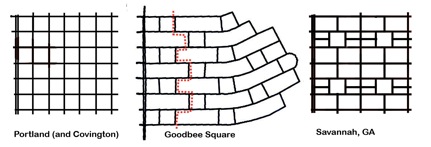
His whole mission is to derail theories surrounding urban planning. His public enemies: density as a positive urban attribute, Portland, mass transit as something other than a tourist shuttle, any government intervention in land use, to name just a few.

Let me spare you most of the heavy reading: the site is a joke. It's intellectually dishonest as it absolutely bludgeons you with study after study, site after site of urban theories "disproven". Usually, demographics, as it were, are the culprits for condemnations of urbanism. You know, density causes poverty, right?

Anyhow, the pinnacle of it all that does deserve a click is his rental car tours of various cities across the world.

He labors to show that Boston is less dense than Los Angeles, though he somehow rambles his way through a couple pages without ever realizing he's admitted the central city is pretty dense, especially by American standards.

He calls Brasilia, Brazil--that country's capital, planned in the mid-century according to the autocentric "skyscrapers in a park" model of Le Corbusier--an unlikely merger of walkability and drivability. While Brasilia seems to have an impressive stock of modernist architecture, I doubt that its mini-interstates offer much in the way of a pedestrian culture. Not that that's really on Cox's mind, though.

Finally, he stops in St. Louis, which he compares to Carthage due to its population loss. Keep in mind, with every city, planners have done everything wrong, except when they've planned for automobiles in places with the right demographics--so he then can say that that automobility is what people want and it works.

Why a "rental car" tour? Because, unfortunately to Cox, tourists are typically subjected to mass transit, which is "a great way to the city as it used to be"--the historic cores. But now, he says, it is not representative of the fact that everywhere has sprawl, and a lot of it. By his logic, that's the building style of choice, where, away from the auspices of invasive planners peddling a lifestyle, community really happens.

Taking it all in, I liken Cox, and much of America, as can be seen on any media outlet, to a scrambling and fidgety crack addict. They're addicted to cars, the personal liberties they afford, and they have the greatest and most pressing agenda to cover up the social costs of a society utterly reliant on automobility. I am not merely talking environmental effects--surely, down the road, hydrogen fuel cell cars will replace the auto giants as they die a horrible, noisy, and painful death as defunct industries. I am talking political, social, and cultural effects--the privatization of our democracy.

The car has conveniently allowed many of us--most of us--to further stack already hectic schedules that become dependent on the speed and convenience of auto transport. It has allowed us a personal pod through which to avoid interactions that might be had on a bus, or a subway train, or some other form of mass transit. It has allowed us to retreat from our democratic ideals of community-building and instead to adopt a "what's in it for me?" mentality not just about government, but in our own lives as well.

When I see the talking heads on the news rattle on about gas prices and what do we do and how do we do it and how can we get back in our cars and oh, why me and pain at the pump and videos of people at gas stations saying I can't do this much longer...I really see the shriveled up crack addict rocking in the corner.

No, Mr. Cox, the government shouldn't force new urbanism down your throat. But it also shouldn't take a neutral stance when so much is at stake. Incentives, if you agree that there should be any for development, should go to the "smart growth" policies you so despise. I am "pro-choice" as well--but I think the supply side should not have received so many subsidies. No matter though--Cox is just another addict, pushing his own lifestyle on other people by way of bunk science and demographics.

Sadly, we, St. Louis, are responsible for him.

Monday, June 9, 2008

Tucker Boulevard should be, could be an urban street...

..if not for things like this:


That's the rendering for the new parking garage at Tucker and Clark. Even the announcement that the garage will feature LED lighting (changed periodically for sports and civic events) is simply not enough to distract from the simple fact that downtown needs no new parking provisions at all.

It should be clear enough by now that the more "convenient" (read: plentiful, cheap) parking is in an urban area, the less urban that area becomes. Visitors to and even residents of downtown may find it easier to drive everywhere and walk the least amount possible. All of the potential points between point A and point B are missed, leading to squandered opportunities for urbanism.

I saw the pared down plans for the Tucker facade of Park Pacific on Downtown St. Louis Business, and I am not impressed either. Another parking garage to front Tucker?

Already, the two bare minimalist high rises on Tucker just north of Chestnut and Pine are perhaps the most hideous high profile buildings anywhere--this coming from a supporter of mid-century modernism, mind you.

Tucker is so wide it appears to spar with Market Street for the title of preeminent downtown boulevard. It is tempting to say that the parking garage is better than the surface lot, but the surface lot is much more likely to be turned into offices, residential, clean industry, shops, or all of the above in the farther future.

We do not need two extra parking garages on this nearly (urbanistically speaking) dead street. It has the potential to be a real showcase street--a moniker New Orleans' similarly wide Canal Street is fighting valiantly to attain once more.

Sunday, May 11, 2008

Carfree in New Orleans

It's often said that urbanists with cars are hypocrites.

Make that one less swerving, cussing, cell-phoning hypocrite on the roads of New Orleans. The car broke down into a billowy smoke stack last week. It's time to sell it and move on.

Despite potholes that could double as foxholes, unexpected monsoon rains, and a humid air often described as "clam chowder", my summer in New Orleans will very likely be spent biking and walking.

Which means, I need a bike. ASAP.

I will see you all in St. Louis on May 16th.

No thank you, Enterprise. I'm hopping on the Amtrak!

Friday, March 14, 2008

Bohemian Hill, Part II

As promised earlier, here is the second part of my October 2007 post on the demise of Bohemian Hill (sans preachy intro--thank God!). If you'd like to view part one, click here.

There seems to be a bit of confusion as to the ultimate fate of the buildings along Tucker Boulevard–some of Bohemian Hill’s last remaining housing. After a battle with Jim Roos (who had the building facing the I-44/I-55 interchange painted with the words “stop eminent domain abuse” inexplicably crossed out) and concerned residents, the city has apparently, for now, given up on its quest to seize these houses.

Bohemian Hill, what’s left of it, that is, is far from safe though. With the departure of the Century Building and its onetime ground floor tenant Walgreens, the city of St. Louis has not one Walgreens that has “hermit crabbed” into an older structure. All are new construction, and all new Walgreens have the same basic architectural elements, if ascribing the word “architecture” to such formulaic construction is even accurate in the first place. Perhaps more importantly, not one has a truly urban format.

I suppose the most walkable Walgreens is Grand and Gravois, which has an entrance that abuts the sidewalk along Gravois. It pains me to give that Walgreens site any sort of distinction though in light of its builders bullheaded, shortsighted, and downright asinine insistence upon pressing for demolition of the now-rehabbed art-deco beauty once known as the Southside National Bank building, a.k.a. the South Side Tower. Luckily the effort failed and they were relegated to the side of a major street just steps away from the corner of Grand and Gravois. Of course, as you know, Walgreens stores can’t succeed without a high profile, visible corner. Let the eye-rolling begin: the “Grand and Gravois” Walgreens is doing just fine.

But I digress. Needless to say, when Walgreens sets a footprint on Bohemian Hill, even if it is as currently planned (to build around the existing structures), that shrivel of a context of a neighborhood will be lost. We cannot have a generic Walgreens as a neighbor to these buildings. Simply put, what is right now difficult to recognize as a part of greater Frenchtown will appear even more out of place next to a suburban Walgreens store.

Plus, there is the thought that Gilded Age/Koman will design the shopping complex (known as Georgian Square) with loading docks facing 13th Street, thus visually polluting the properties along that street, including the year 2000-constructed infill housing, with the hope of convincing owners to sell for future shopping center expansion opportunities. I would list these properties as endangered.

The current site plan, however, makes it difficult to determine what the intent of the developers is. Since the city’s announcement that it will not seek to buy out the Bohemian Hill homes, Gilded Age/Koman has not released renderings that reflect the preservation of these homes.

From Koman’s website:


Buildings “H” through “M” would clear everything on the site. By the renderings, 13th street looks to be street level retail, even mixed use with residential atop. Who knows what to trust? Renderings are so temporary.

The point of these posts is not to chase away investment from St. Louis, as some of my detractors have said. Sure, I do think that these large developments that invite all the typical chains into the urban landscape (Starbucks, Panera, Walgreens, Qdoba) without the urban form are misguided and not necessarily good at all for our city. Still, I’m sure residents of the surrounding neighborhoods will be pleased to have a grocery store in the immediate neighborhood. When I lived in the 1000 block of Dolman in Lafayette Square, I used to either walk to the Salama Market (a small and to my knowledge local chain serving mostly Clinton Peabody residents, located on Chouteau at the end of the new Truman Parkway), drive to City Grocers if it was just an item or two, or I would drive to the Schnucks at Grand and Potomac. Blech, by the way on that last one.

Shooing away development dollars and needed services is not the message from atop my soapbox. What I hope to bring to your attention is the opportunity (the need?) for the city to work with the developer to provide a different site–or to integrate their retail with the reestablishment of Bohemian Hill as a residential neighborhood.

After all, South African architect Jo Noero developed a site plan for Bohemian Hill that envisioned a neighborhood punctuated with infill housing not unlike what sits today on S. 13th Street just south of Lafayette. Of course, in 2001, when the Missouri Alliance for Historic Preservation recognized the site plan as a recipient of the McReynold’s award for architectural preservation, much more of Bohemian Hill’s older housing stock was present.

Read the story here and see the site plan below.


Unfortunately, this small, blurry photo is all I can offer. Still, imagine the possibilities of creating a new mixed use neighborhood, having preserved all of the old in the process. In my opinion, Noero’s models are splendid urban homes that evoke elements of the old while retaining a distinct post-post-modern look. Imagine a neighborhood that included these houses and incorporated the larger retail proposed by Koman/Gilded Age on the larger corner lots at Lafayette and Tucker and Lafayette and 13th?


Courtesy of Rob Powers’ Built St. Louis

Isn’t it sad that in St. Louis today, that kind of development is expressly unthinkable–even forbidden by outmoded zoning?

This retail could have gone into a reformatted I-44/55 interchange (which needs to happen anyway–what a waste of land!). It could have even gone into the wedge along the western side of Truman Parkway with some skilled planning. Or hey–how about building onto the massive parking lot behind the Georgian (former City Hospital) and replacing it with retail buildings and structured parking?

Oh…I forgot for a second. Visibility and extra parking is more important than the legacy of one of St. Louis’s fine and nearly forgotten neighborhoods.

Fashion STL Style!

Fashion STL Style!
St. Louis Gives You the Shirt Off of Its Own Back!

Next American City

Next American City
Your Go-To Source for Urban Affairs

Join the StreetsBlog Network!

Join the StreetsBlog Network!
Your Source for Livable Streets

Trust in Rust!

Trust in Rust!
News from the Rustbelt

Dotage St. Louis -- Blogging the St. Louis Built Environment Since 2008

Topics: Historic Preservation, Politics and Government, Development, Architecture, Urban Planning, Urban Design, Local Business, Crime and Safety, Neighborhoods, and Anything Else Relating to Making St. Louis a Better City!