Search This Blog (A.K.A. "I Dote On...")
Monday, February 22, 2010
Submit Your Bicycle/Pedestrian Improvement Project to MODOT! 2:21 PM
Please, do the City of St. Louis a favor and submit a project!
There are some ground rules. Read them and submit your project here.
One requirement is that your proposal directly affect the MODOT system. So, for example, bike lanes on Lindell might sound great, but Lindell is not a state or federal road.
Try to think of ideas along the interstate system, but especially on one of the state-maintained roads within the City of St. Louis. These include:
> Missouri 30 - Gravois Avenue
> Missouri 100 - Chouteau/Manchester Avenues
> Missouri 115 - Natural Bridge Avenue
> Missouri 180 - From Goodfellow west to city limits on Martin Luther King, Jr. Blvd.
> Missouri 267 - A portion of South Broadway in Carondelet/the Patch
> Missouri 366 - Chippewa Street
I submitted a proposal to install a planted median in the center of Gravois from Taft Avenue on the north to Christy Boulevard on the south. This would reduce traffic lanes on Gravois, provide a pedestrian crossing, beautify the area, and connect the Christy greenway and bike lanes to the Bevo neighborhood.
Please submit your own project ideas! St. Louis needs you right now, as the vast majority of submissions are coming from Kansas City and St. Joseph! If you need examples, click here for previously submitted projects (including mine).
Wednesday, October 28, 2009
The St. Louis Mile: Longer Than 5,280 Feet? 6:08 PM
Citing my own mix of experience in studying Jane Jacobs and urbanism, as well as being a pretty well-travelled pedestrian in both St. Louis and New Orleans, I would list the following on my "walkability" check list:
- Manageable building heights, with any towers stepped back from the "base". Personally, for both walking and living, I prefer roomier and quainter residential districts and neighborhood-scale commercial areas to mid- and high-rise districts anyway.
- The street should either be narrow enough to slow traffic, or have traffic slow enough to make me feel safe crossing right after a yellow light.
- Of course, street trees serve multiple purposes for pedestrians: beautification, shade, rain barriers, buffer from cars, etc.
- Seeing other people walking or having other visual interest and activity around makes walking less monotonous.
- Building designs, from block to block, are hopefully varied and interesting as much as the activity on the street.
But the most important point is that there be a lot of corners. As a friend of mine here in New Orleans noted, corners are the lifeblood of urbanism. A plurality of them means more opportunities for neighborhood commerce and exchange, whether that's said in the literal sense (retail, restaurant, etc.) or the sense of community, wherein people "run into" one another and strike up conversations upon turning a corner.
Street corners force automobiles and other traffic to be more vigilant, especially the more of them there are and the more automobiles clamoring to get on one of the main roads. Almost no matter what, corners display the visual complexity of urban life. The best moment as a pedestrian (especially a leisurely pedestrian not in a time crunch) is to happen upon a busy corner and to be literally drawn in each direction to the point of having to halt in the middle of the sidewalk to decide if that corner over there merits a jaunt just to check things out.
In St. Louis, I think automatically to:
View Larger Map
Or perhaps less obviously:
View Larger Map
Either way, my "explorer" alarm goes off when I see such interesting things on all four corners (bonus points go to traffic circles that form super-intersections that remain pedestrian-friendly).
The reality is that St. Louis doesn't meet all of my requirements for full pedestrian comfort just yet. That's all right, as many areas are slowly getting there (Forest Park Southeast, Tower Grove South along Morgan Ford, etc.). Yet one problem with St. Louis's corner-making potential is that the blocks that feed into the mixed-use districts tend to be too long. In nearly all areas outside of St. Louis's old Creole street grid (Soulard, Old North, and Downtown), we have long "Victorian" blocks that were laid out with the notion of keeping activity (whether that activity is through pedestrians, streetcars, or vehicles) on shorter main roads with more corners.
To return to Maryland and Euclid in the Central West End:

You'll notice that the "walkable" block (north-south) is Euclid, while the residential streets are nearly double the length and therefore less walkable. That means I have to amble twice as far to find the activity and vibrancy than if I were walking down Euclid (throw on top of this argument the fact that private or closed-off streets make a lot of pedestrians feel uncomfortable and unwelcome). Cherokee's situation is reversed in directionality, but is the same for all practical purposes. North-south streets are long, while intersecting east-west blocks with more commercial uses are short. It seems ingenious, and does contribute to walkable "strips" of activity.
But my contention is not that Cherokee, or Euclid, are not walkable streets. I feel that the city as a whole has committed the number one sin of walkability: making distances seem farther than they really are.
I've noted on this blog before the issue with long blocks (Jane Jacobs is not a fan, either). For drivers and for pedestrians, they offer fewer routes to get to the same place, thereby concentrating activity on the main drags. This is great for the driver of a vehicle who wants to, say, park on the northern end of Euclid (say, Delmar), get out of a car, and walk the strip down to Maryland Avenue. But for those who live technically within a sensible American walkable range (1/2 mile), their options for getting to Euclid and Maryland are probably insufficiently diverse as to ensure they walk every time if they still own a car. It doesn't help that it's often not very difficult to find a parking spot anywhere in St. Louis. That's a separate (albeit related) issue that I hear a lot of urbanists comment upon. I hear less about the perception of distance in St. Louis, which may be more related to long blocks than we think. A study is definitely needed.
To wit: when friends from St. Louis visit New Orleans, I usually forewarn them that when I say we're walking to a place that's "only 12 blocks away", it means we're roughly "six St. Louis blocks" from our destination. The number sounds scary to the inexperienced pedestrian, but the constant interest of the intersecting streets and their corners (not to mention the activity and the nearly universal human scale architecture) ease the pain a lot. For St. Louis, I fear a mile seems much beyond the traditional 5,280 feet metric in pedestrian psychology.
Maybe one reason folks don't talk about the problem of long blocks in St. Louis is that, well, it's an intractable one. Few people these days would argue we need to tear down houses in Tower Grove Heights to create new corners and through-ways (I wouldn't!). And pedestrian pathways, while nice features on overly long blocks, usually suffer from a look of privacy and, (as in the Northampton neighborhood's walk ways) and do not create corners in the traditional sense.
We could look to this interesting case out of the suburbs of New Orleans for some of our more tattered neighborhoods: the "Goodbee Square" in Covington, Louisiana. In this system, a grid is staggered to make north-south travel (in this case) inefficient for vehicles. While the article goes on to suggest that pedestrian paths should be created for such a system to make walking easier, a slight modification of such a grid could produce logical pedestrian paths, more corners, and at the same time make sure the new roads aren't used as cut-throughs exclusively. See below:
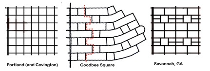
For intact neighborhoods, it's a matter of getting more people walking and returning corner mixed-use properties back to commercial life. Even if the grid itself can't be altered, a return to widespread commercial properties will still lend each block with a solid corner a degree of urban excitement, randomness, and possibility of discovery that St. Louis so needs.
It's a matter of public art, whether on sidewalks, in varied tree plantings, on the streets, fire hydrants, in gardens, even streetlights...St. Louis needs much more unexpected bursts of color and life.
Some neighborhoods, such as Forest Park Southeast, Downtown, and Old North, have various forms of themed walking trails. These are delineated by signs and markers. They make the unsuspecting pedestrian passer-by curious and might spawn further exploration. In other neighborhoods, removing concrete barriers and allowing vehicular traffic back through will strip these streets of their "semi-private" status and encourage more walkers. And I'm always an advocate of re-styling or removing altogether certain members of our much too intrusive interstate system, which creates wide psychological gaps as well (how far apart do Shaw and old McRee Town seem to you?).
The best way to reduce the St. Louis mile, if you're interested, is to walk anyway. Active streets are interesting streets. But it wouldn't hurt for you to create that interesting sidewalk art. Or plant that garden. Or plan the walking trail. Or lobby to patch up our tattered street grid. By then, hopefully walking will be so pleasant we won't even be thinking about how many more steps and blocks it is to that ultimate destination.
Tuesday, September 22, 2009
Forest Park's Biggest Flaw - Now Never to Be Corrected? 2:00 PM
(Okay, I could complain a bit here. Other large municipal parks have cut down on paved roads and turned the park into more of an urban, pedestrian-friendly destination. And, as St. Louis Urban Workshop notes on his blog, Forest Park could definitely feature more spaces in which to simply hang out and people watch.)
To me, the biggest flaw of Forest Park is a somewhat disappointing connection to nearby neighborhoods. On each side, there's an issue.
On the west (Skinker Boulevard), you have an overly wide road that does carry a high volume of traffic. It's noisy, difficult to cross during the day, and somewhat uninviting, though a tree canopy helps a bit. Regardless, this edge of the park appears the most active and therefore enticing. It's no doubt bolstered by the presence of Washington University at its doorstep and all of its students/faculty.
On the north (Lindell), there are beautiful, stately homes, but I have never seen much activity flow out of these single-family manses. I always wonder if this portion of Lindell had developed as Pershing (formerly Berling) did, with all of its mid-rises, what Forest Park's northern edge might be like. It would have been wonderful to be able to sit at a sidewalk cafe patio and stare into the park, urbanely surrounded by an attractive turn-of-the-century skyline. Don't get me wrong, the present homes are splendid; my feelings toward them are not exactly ambivalent. I just wonder how they could be employed to make Forest Park's northern edge even better. I'm excited by the possibility of the proposed Delmar Loop Streetcar continuing eastward from DeBaliviere on Lindell and into the Central West End. In New Orleans, the St. Charles Avenue streetcar carts tourists and locals alike who, cameras in hand, enjoy gawking at inconceivable wealth and their historic mansions. Could St. Louis have its own version of this pleasant, tourist-friendly transit ride? I think so.

A St. Charles Avenue streetcar passes in front of one of the many mansions on the famous street. Source.
The east side of Forest Park (Kingshighway) is an interesting case. Just to the northeast sits one of St. Louis's mostly densely-walked neighborhoods and just to the east is the well-trafficked Medical District. You would think the east side of Forest Park would be filled with sauntering pedestrians. Yet, when you look at the topography, you see why. There are definite grade issues with the eastern side of the park, which slopes significantly downward from the Kingshighway elevation. Plus, the Metrolink railroad tracks slice off a portion of Forest Park, dividing the two sections from pedestrian access.
Of all of the neighborhood connectivity issues with Forest Park, the south side of the park (Oakland/I-64) is the worst. Why? Because there's an interstate highway blocking the following from walking to and directly enjoying their park with ease and without a car: Forest Park Southeast neighborhood (ironic, right?), St. Louis University High School, the Science Center, Compton-Drew, St. Louis Community College's Forest Park campus, the King's Oak and Cheltenham neighborhoods, the old Arena site's Highlands development, Forest Park Hospital, the Dogtown neighborhoods, Turtle Park, and points west. I cannot help but think that the south side of the park would usurp the title from the west for most active if Oakland, rather than I-64, were the point of crossing into the park (as it once was).
So when I read the following Post-Dispatch headline I was disappointed:
Highway 40 project head to lead Forest Park group
All urbanists should be frustrated that the Missouri Department of Transportation thought it worthwhile to rebuild several miles of I-64 almost exactly as it was to the tune of $535 million. Sure there are now soundwalls and somewhat less egregiously land-wasteful interchanges. Great. But if there were one section of the interstate that should not have been rebuilt as it was, it was the stretch that fronts Forest Park! Yet now, Lesley Hoffarth, manager of that woebegotten "New I-64" project, will head Forest Park Forever, the advocacy group and ersatz management of the park.
It astounds me that there was such a fight to rescue Hudlin Park (a portion of the park stranded by both a re-routing of Kingshighway and the construction of I-64) when the "New I-64" project was a real chance to take back a huge chunk of the park.
With the money spent adding even more highway lanes to a region that simply doesn't need them, I-64 could have been tunneled, reconnecting Forest Park to its southern neighbors and institutions.
Now, I don't know Lesley Hoffarth, and she may be more urban-minded than I'm aware. But any head of Forest Park Forever, a group that has done great work strengthening and improving the innards of the park, should know that its edges are important too.
The greatest improvement that could come to Forest Park would be the removal of I-64, at least visually, from the southern end of Forest Park.
Not that I think this concept ever held much weight in an autocentric region, but I worry now that this "radical" idea may now never get airtime. At any rate, the finishing touches are adorning the rebuilt stretch from I-170 to Kingshighway. Many would call it more than wasteful to suggest that this freshly redone section now be covered up.
But I say, the sooner the better. We need not live in the shadows of bad planning simply to justify the costs of a worthless effort.
Wednesday, September 2, 2009
United States Postal Service To Close 9 St. Louis Area Post Offices; 5 in the City 5:32 PM
I get that the USPS is probably looking at consolidating offices for "efficiency" purposes. But I doubt they looked into the effects of the loss of walkable post office locations. The loss of the South Grand location--along the busy Grand South Grand stretch--is especially upsetting. So too is the blow to the Baden Business District, which just revived its neighborhood street festival, Badenfest. While Soulard's station was tucked away in east of 7th Street (actually the Kosciusko Industrial area), it was still walkable to that neighborhood's residents. It's a shame to see such community-based amenities go.
Monday, August 3, 2009
Skinnytown Sculptures / South Grand Road Diet 11:53 PM

In other Tower Grove South news, South Grand is going on a road diet and you, St. Louis, can vote on the resulting slimmer design at an upcoming public meeting. I hear high-tech touch pads will be used for the voting process. Here's a cut-and-paste of the meeting announcement from the Tower Grove South website:
GREAT STREETS INITIATIVE SOUTH GRAND: Public Meeting and Design Charrette Announcement
Good Evening Everyone,
Please accept the attached postcard as an invitation to participate in the Public Meetings and Design Charrette scheduled for Monday, August 10, 2009 – Wednesday, August 12, 2009 from 4:00PM to 7:00PM. Also, please share the postcard flyer with your constituents so that they may have the opportunity to participate in the meetings as well. Should you have any comments or question, please give us a call at (314) 436-3311. We appreciate your immediate attention to this matter, and we look forward to meeting you.
Bridgett S. Willis
Hudson and Associates, LLC
1204 Washington Ave., Ste. 402
St. Louis, MO 63103
Office: 314-436-3311
Fax: 314-436-3503
Cell: 618-560-3225
Maybe a slimmed down South Grand will be able to compete with the charming, wacky Skinnytown along Morganford?
Sunday, July 19, 2009
The St. Louis Business District: Walkable, but is it Walked? 9:16 PM
Pittsburgh has about 310,000 residents at last Census count. Its metropolitan region has 2.4 million. St. Louis has about 355,000 residents with an area of around 3 million.
So what gives? Without delving into the two cities' respective histories and demographies, I want to know what your ideas are for increasing St. Louis's pedestrian friendliness with the ultimate goal of increasing the number of pedestrians. I know crime, racial tensions, weather, overly wide streets, lack of pedestrian amenities, lack of vital public spaces and other factors hold St. Louis down to a degree that Pittsburgh just does not.
But it is amazing to me that a city of St. Louis's size, compared to Pittsburgh, has only the Loop as a traditional urban business district where one can walk several blocks and see dozens of other individuals walking with them.
A lot of St. Louis's problems seem to rest in its leaders and residents' belief in the mantra: if you provide parking, they will come. Yet, as we can see with the popularity of the Delmar Loop, it's the goal of having a commercial street with high foot traffic that really draws people. The people-watching appeal is undeniable when walking through any commercial area--whether a mall, the Loop, or Carson Street in Pittsburgh. Yet St. Louis's leaders (and even residents, often) are complicit in providing plentiful parking spaces.
New Orleans's Magazine Street is another great example. In its six miles, most of it retail and mixed use buildings, there are no parking garages. The street is active and heavily foot-trafficked.
St. Louisans also often cite a lack of parking as the reason for a particular business's failure. Yet is the equation that simple? Might that driving customer have struggled to find a space (what--2 blocks away tops?) if that same place had an awesome sign out front that drew them in; had amazing customer service or a unique product; had several stores and restaurants nearby to make the parking experience worthwhile? Better yet, what if more residents surrounding the establishment had walked from home?
Having visited and lived in cities of similar size to St. Louis--Pittsburgh and New Orleans--I have to say that this is one of St. Louis's greatest downfalls and one of its biggest detractors from claiming urbanism. There is a pronounced dearth of healthy business districts that are not only walkable (Manchester, Macklind, South Grand) but also regularly walked. Luckily, this seems to be slowly changing as some commercial areas become more popular and see new business openings (see previous three examples).
Yet the model of reinvigoration of a St. Louis business district always seems contingent on developing "destinations" out of individual buildings rather than marketing the whole district as a commodity. This leads to adjacent parking lots and the notion that a business district must "graduate" to walkability only after being deemed a "parkable" destination.
I have much hope for Cherokee Street as St. Louis's first and foremost example of relatively unbroken, walkable, and walked urbanism outside the Loop and Euclid in the CWE. With the Great Streets Initiative, South Grand could finally reach the critical mass of pedestrians as well. And North 14th Street in Old North at least sports the two blocks with an almost intact street wall.
Where do you fall on this discussion? Should we allow parking lots for the burgeoning district to reel people in, then allow demand to the fill those parking lots in with buildings? Or should we aggressively market existing business districts as urban places and significantly restrict all but on-street parking in order to encourage a) people to park farther away and therefore walk farther, b) people to simply walk to the district if they are within, say, one half mile distance, and c) people to take mass transit to arrive at these business districts?
Saturday, January 17, 2009
New Orleans' Harrison Avenue is a good model for parking in suburban business districts 1:00 PM
Harrison Avenue is located in a section of New Orleans known as Lakeview. Lakeview was one of the most inundated neighborhoods following Hurricane Katrina. Always a middle class, semi-suburban area, the neighborhood has bounced back significantly and continue to rebuild.
Harrison Avenue is a five-block long business district that has a somewhat peculiar parking arrangement. New Orleans' famous wide medians are hollowed out and used for parking in this district. This might sound ugly, but I do think it accomplished a lot of things. For one, it is useful in districts where plentiful parking is expected and needed, and it mostly avoids the need to place front-facing surface lots to the street. Secondly, it screens the parking from both the automobile occupant and the pedestrian. Third, the narrow strip of parking functions almost as a calm "street within a street", very likely reducing traffic accidents.
Let's take a look at some pictures of the area and the parking set-up.
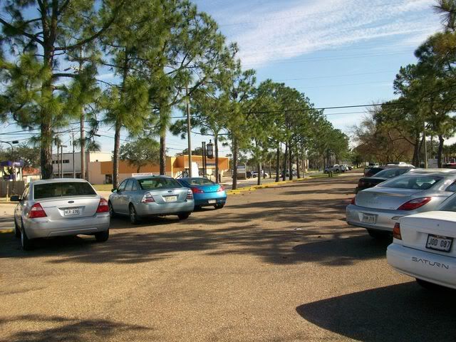
This is a look down one of the rows of in-median parking. As you can see, the median provides quite a few parking spaces--along with greenery--to the business district. The street is approximately 120 feet wide, with 55 feet taken up by the median.
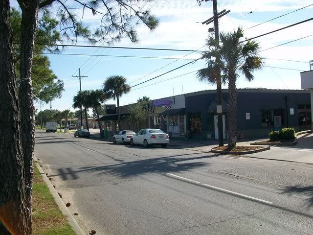
This is a view from the median to the business district. If the street did not sport the median, this stretch would look like an interstate. Many of the buildings are early suburban commercial buildings. These retained urban street frontage, even as squat, one story commercial structures.
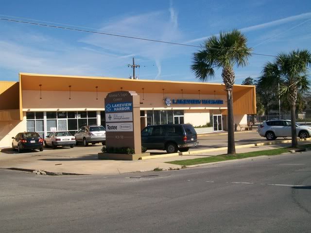
This is a photograph of a more suburban-formatted shopping center along the road. Since this was an area built up primarily post-1930, these structures truly have a context. That doesn't necessarily mean that this business district couldn't use a little reformatting to take advantage of the added parking spaces in this central median. Front lots such as this one are likely unnecessary when combining on-street parking with the median.
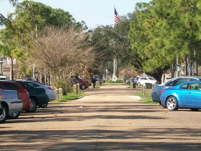
The view down the median is impressive. It almost looks like some rural parkway with all of the pines.

The mature trees in the median-area are a welcome feature of the median.
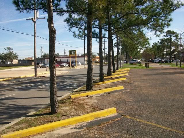
This is a great way to both take attention off of the cars in the parking area as well as filter the emissions that automobiles bring with them.

Here's a bonus--an excellent Miami Deco/Moderne bank in the business district.
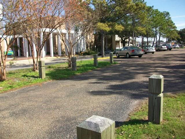
Finally, here's a shot of one of the entrances into the parking median.
I would like to see such a median placed on Hampton Avenue in St. Louis. It has a somewhat similar profile to Harrison. There are a lot of squat commercial buildings close to the sidewalk, but also mid-century retail buildings pushed back from the street with front-facing parking.
View Larger Map
Imagine the same type of median on this stretch of Hampton. The traffic here is not heavy, but does move rather quickly. The amount of roadway surrendered to the median would invariably reduce driving lines and therefore speed as well. In short, it makes for a much friendlier pedestrian environment where driving passers-by will more likely see the businesses along the street--and have convenient parking too. To me, it's a true win-win in districts of this late urban/semi-suburban profile.
Hampton is much narrower than Harrison (about 60 feet across, from curb to curb) in its southern reaches. Still, a one-lane version of Harrison Avenue's parking median could work (thereby halving the size) from Loughborough on the south up to Nottingham on the north.
Friday, September 12, 2008
The CVS Mess 10:47 PM
This sounds great, right? Here's the site:
View Larger Map
Of course, there's a Walgreens adjacent to this site (spin the Google Streetview Map around to see it)--not to mention the Schnucks, which carries pharmaceutical goods, right across the street.
But never mind the oversaturation of pharmacies for a moment. They're taking five homes to build this store too! God help me if they're getting any sort of incentives from the city to do so!
Look: I want competition for Walgreens. Their rampant expansion has blighted several neighborhood corners with a highly successful, but generic store that only hurts already scarce local retailers and pharmacy. See the Martin Luther King shopping center on North Grand as an example. They knock out a turn of the century commercial building (or two, or three, or four) to put up a cinderblock store with front parking--a forgettable addition to a neighborhood that needs bold change. On the south side, they built another atrocious store on the corner of Kingshighway and Chippewa--despite pleas of neighborhood residents for that corner to be reserved for architecturally interesting and urban construction after the failed K-Mart proposal in the late 1990s.
The last time I was in town, I tried to convert my parents to using local pharmacies. Guess what--they're the same price (if you have insurance) and they deliver!
Try Keller Apothecary on Brannon and Chippewa, or Lindenwood Drug at Lansdowne and Jamieson.
My point is: I have no qualms about threatening Walgreens' near monopoly on drugs and junk-peddling retail. I just don't want it to be CVS to do it! Especially not in a city like St. Louis that has shown a consistent failure to support urban storefronts and sound design. If we keep building like a suburb, we will never host walkable, urban neighborhoods. The line between suburban St. Louis and urban St. Louis will further blur until the once-grand city becomes merely a tired-looking caricature of Sunbelt Sprawl. Proper zoning (and leadership) would ensure that CVS would build urban and attractive. And it would most likely not allow the loss of homes in a stable neighborhood for such gratuitous duplication of services.
This is a Maps.Live view of at least two of the homes to be demolished. These are along Austria Avenue.
They may not be gems, but they shouldn't be torn down for a suburban-style pharmacy. That's a story St. Louis knows too well.
Luckily, to my knowledge, there are no renderings yet, and we can perhaps voice our concern that this project will clog an already busy street and should therefore be made as pedestrian-friendly as possible (not to mention well-designed aesthetically). Oh yeah...pssst...it's right across the street from a transit station...
Join me in contacting 12th Ward Alderman Fred Heitert to pass along these concerns.
Sunday, July 6, 2008
Corner-hugging buildings to be extinct in St. Louis? 12:20 PM
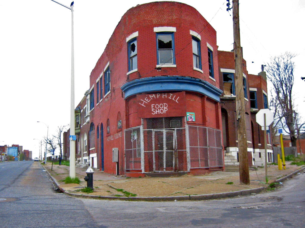
And another heartbreaker:
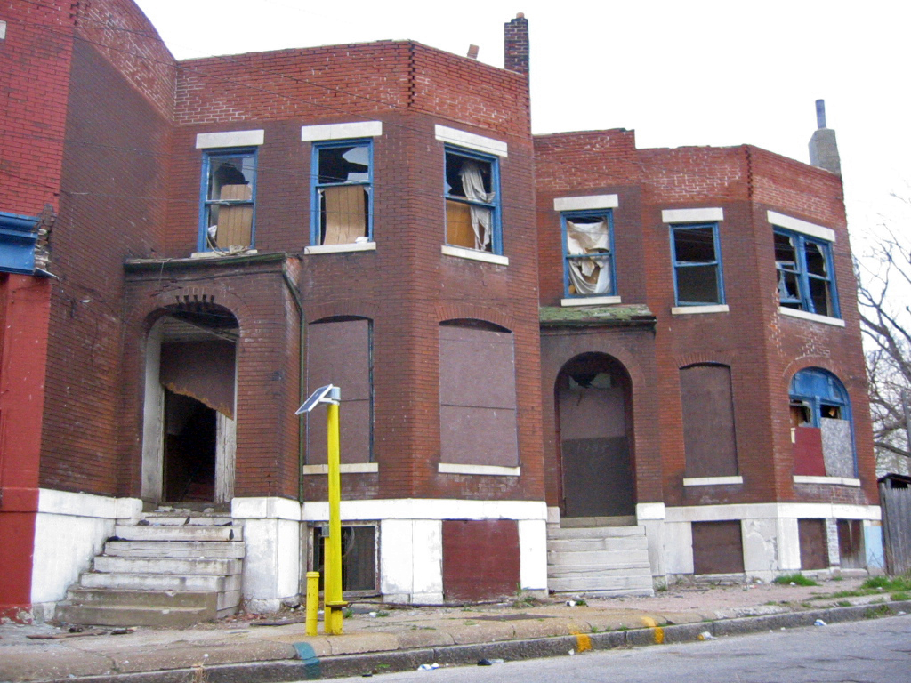 Look at the carefully calculated recess from public to private space that these units offer. It is not just a cynical statement to say that nothing with such attention to delightful nuance will ever occupy this spot again.
These cleverly curvaceous buildings remind me of the Fountain Park beauty rightfully lauded once upon a time by B.E.L.T.'s Toby Weiss:

Thank the heavens that this one has not yet seen "emergency" demolition! The pleasant building seems to literally embrace the oblong Fountain Park that is its neighbor. With any luck, it will get snapped up by some enterprising developer or some passionate resident with some spare change and time.
Let's jump back to the first example, located at MLK Jr. Blvd. and Glasgow:
View Larger Map
Take a look around. The city has respected the legacy of Dr. Martin Luther King Jr. enough to repave the street, replace sidewalks, introduce ADA compliance, and add historic-esque street lighting.
Do these infrastructure improvements even matter when we erase places, when we pull down old buildings for no reason, with no plans?
More innovative leadership is needed to deal with a decaying, but irreplaceable stock of buildings in the city of St. Louis. A passive Building Division cannot engage in preservation advocacy, and our Preservation Board was designed to be "balanced" (meaning that there would have to be members whose interests are seen as counter to preservation--like realtor Mary "One" Johnson). Therefore, citizens need to both demand better leadership that has a better grip on what type of future residents want for their city AND to lead by example themselves.
That vacant lot at Glasgow and MLK, Jr. was a clear net loss for the city.
So why are we silent?
I am going to do a bit of research on the myriad ways other cities deal with vacant, but historic buildings. Look for a series in the future from me about "unlikely" preservation successes--that is, when people see potential and do not let it slip away. Perhaps in light of the 2008 presidential election, and specifically its Democratic nominee's slogan, I'll call the series, "Yes, We Can!"
Thursday, April 3, 2008
No such thing as "aldermanic advocacy" 11:26 AM
What is "it"? The East-West Gateway's Great Streets Initiative, and specifically, the proposed streetscape improvements to Grand South Grand.
Shouldn't our leaders be advocates for better and safer design, for a pleasant streetscape that complements one of St. Louis's most bustling, exciting districts? Or could it be that the alderwoman is afraid that some residents will vote her out for slowing down their too-fast morning commutes on the superhighway that is the current South Grand?


