Search This Blog (A.K.A. "I Dote On...")
Wednesday, March 3, 2010
Brilliant Urban Design in the St. Louis of the Past 2:43 PM
Monday, February 22, 2010
Submit Your Bicycle/Pedestrian Improvement Project to MODOT! 2:21 PM
Please, do the City of St. Louis a favor and submit a project!
There are some ground rules. Read them and submit your project here.
One requirement is that your proposal directly affect the MODOT system. So, for example, bike lanes on Lindell might sound great, but Lindell is not a state or federal road.
Try to think of ideas along the interstate system, but especially on one of the state-maintained roads within the City of St. Louis. These include:
> Missouri 30 - Gravois Avenue
> Missouri 100 - Chouteau/Manchester Avenues
> Missouri 115 - Natural Bridge Avenue
> Missouri 180 - From Goodfellow west to city limits on Martin Luther King, Jr. Blvd.
> Missouri 267 - A portion of South Broadway in Carondelet/the Patch
> Missouri 366 - Chippewa Street
I submitted a proposal to install a planted median in the center of Gravois from Taft Avenue on the north to Christy Boulevard on the south. This would reduce traffic lanes on Gravois, provide a pedestrian crossing, beautify the area, and connect the Christy greenway and bike lanes to the Bevo neighborhood.
Please submit your own project ideas! St. Louis needs you right now, as the vast majority of submissions are coming from Kansas City and St. Joseph! If you need examples, click here for previously submitted projects (including mine).
Wednesday, February 17, 2010
Rants and Raves, Quick and Dirty 1:20 PM
Grand Center--the Intersection of Art and Life--is getting an artless, lifeless streetscape improvement project. New sidewalks, essentially...that's it. See Gateway Streets blog for more details. Why waste the money?
In a 4-3 vote Tuesday, the St. Louis County Council approved the name change of Weber/Carondelet Roads in South County bordering River des Peres to, gulp, River City Casino Boulevard. River City Boulevard? Maybe. The "casino" portion does indeed turn this stretch of road into a billboard. It erases the history and identity of the street so that drivers cannot mistake where they're heading. Anyone ever heard of a directional sign?
Raves
On the other side of Grand Boulevard, in the Grand South Grand strip, things look a bit better. This streetscape project will shrink the bloated roadway without the use of ugly barriers, will plant new trees, install new street furniture, wayfinding signs, etc. Here is the link to the latest presentation on the project, which includes the rendering.
Sappington Farmers' Market is expanding into the city. The market's owners plan to build a two-story structure at the southeast corner of Park Avenue and Truman Parkway in the City Hospital Complex. It'll include 25,000 square feet of retail on the ground floor and an 80,000 square foot greenhouse atop the building. This excellent development should make the Near South Side an even better place to live. Here's to hoping the building is designed well and is urban in form.
Sunday, December 13, 2009
This is St. Louis's Best Street 3:17 AM
Imagine you had a famous urban planner coming in town who wished to get a sense of the city, but s/he only had time to traverse one street, with no deviations from that one street. You're selected as her/his guide. You'd be walking, so would not need to worry about street blockages like barriers and closures.
Which street in St. Louis would be the greatest for telling the story of our city? Ideally this would be a mostly positive experience, but St. Louis has and has had some pretty down moments, so it's expected that you'll run into some trouble spots. But remember the point is to find the most "impressive" street to guide a visitor along. I'll let you define impressive.
Which street do you choose?
Rules: For the road you choose, you must traverse its entire length. For the sake of keeping it interesting, the road must be at least 1 mile long. (Sorry, fans of Hemp Avenue in Forest Park Southeast)! If the street breaks or dog-legs, you are allowed to move around the obstacle and resume the course of the street so long as it retains the same name and is understood to be the same street. You are also allowed to "walk across" interstates.
Saturday, November 14, 2009
Conflicting Goals on Southwest Avenue 6:55 PM
Components of the project include upgrades to the pedestrian signals, crosswalk, and traffic signal timing at the intersection of Kingshighway and Vandeventer, implementation of a road diet along Vandeventer (reducing traffic lanes from 4 to 3, excep at the main intersections), installing new street lights with cut-off fixtures (which will reduce light pollution and increase lighting for the pedestrian), increased plantings of low maintenance ground cover and hardy tree species, reduced curb-cuts, and ADA-compliance.Sounds great--and very necessary, right?
While I'm unsure of the boundaries of the project, it's nevertheless disheartening to see that a portion of Southwest Avenue may soon lose its urban charm and become less friendly to pedestrians even as another section of the road sees an upgrade.
Favazza's restaurant, located at 5201 Southwest, is seeking demolition permits for two neighborhood commercial/mixed use buildings, at 5209 and 5211-13 Southwest according to the latest preliminary Preservation Board Agenda.
These are the buildings in question:
View Larger Map
The full report is not yet online, so the reasons for the requested demolitions are not yet available (anyone want to call Favazza's and ask?). The best guess is, of course, a nice and spacious adjacent parking lot.
Unless the ultimate proposal is new construction on site, which I doubt, Favazza's plans to tear down two pedestrian-oriented buildings on a stretch of road soon to be improved just doesn't make sense. Again assuming a parking lot is coming, the result will be a less walkable, uglier street.
The Hill and adjacent Southwest Garden are thriving St. Louis neighborhoods. Especially in the case of the former, the record has shown that small, storefront retail with limited parking leads to a more walkable and walked neighborhood. The Hill's commercial rows are interesting--and lively for St. Louis, which is mostly starved of the brisk pedestrian traffic of denser cities in the Northeast.
Tearing down two buildings on a strip with major potential is an all around bad idea. Yet it's even less bearable when you consider the waste of public investment in making roads pedestrian friendly and then removing all the reasons pedestrians would ever want to walk them.
I think to Martin Luther King Blvd. from Jefferson to Grand as an example of a pure waste of money whose improvements only brought more attention to the sorry state of buildings along the stretch. The city and some private owners have worked together to strip most of the refurbished street and its sidewalks of any urban buildings that make walking interesting and comfortable, that give small business owners a chance to invite the pedestrians to the stretch in the first place. See what I mean?
View Larger Map
Here, new streetlights and sidewalks only cast light on the emptiness of the surrounding blocks.
My argument is not that disinvested places or streets with few urban buildings do not deserve to have better sidewalks; it's just that there should be a special effort to justify such investment. In other words, keep these roads as urban-formatted and pedestrian friendly as possible! Keep the remaining buildings in place; assign an urban design overlay zone that is very restrictive with regard to parking lots! Simple as that.
The Preservation Board should deny the ridiculous demolition proposals on Southwest Avenue. You may voice the same opinion at the monthly meeting, to be held:
Monday, November 23, 2009
4 p.m.
1015 Locust
Suite 1200
Please show up and protest bad, if typical land use planning in the City of St. Louis. See to it that our commercial corridors are ripe for reinvestment and pedestrians, not drivers and visual blight.
(My apologies in advance if Favazza's is experimenting with radically amazing new construction on site of these two fine buildings and is not, as I suspect, shooting for a parking lot).
Monday, August 3, 2009
Skinnytown Sculptures / South Grand Road Diet 11:53 PM

In other Tower Grove South news, South Grand is going on a road diet and you, St. Louis, can vote on the resulting slimmer design at an upcoming public meeting. I hear high-tech touch pads will be used for the voting process. Here's a cut-and-paste of the meeting announcement from the Tower Grove South website:
GREAT STREETS INITIATIVE SOUTH GRAND: Public Meeting and Design Charrette Announcement
Good Evening Everyone,
Please accept the attached postcard as an invitation to participate in the Public Meetings and Design Charrette scheduled for Monday, August 10, 2009 – Wednesday, August 12, 2009 from 4:00PM to 7:00PM. Also, please share the postcard flyer with your constituents so that they may have the opportunity to participate in the meetings as well. Should you have any comments or question, please give us a call at (314) 436-3311. We appreciate your immediate attention to this matter, and we look forward to meeting you.
Bridgett S. Willis
Hudson and Associates, LLC
1204 Washington Ave., Ste. 402
St. Louis, MO 63103
Office: 314-436-3311
Fax: 314-436-3503
Cell: 618-560-3225
Maybe a slimmed down South Grand will be able to compete with the charming, wacky Skinnytown along Morganford?
Saturday, July 25, 2009
What Would Jefferson Look Like with a Median? 1:21 PM


The above renderings show Jefferson with one lane of travel in each direction as well as one dedicated parking lane. I'm guessing that this would substantially slow the flow of traffic on Jefferson and make the commercial spaces along the stretch much more inviting. In addition, the median would be a great placeholder until the proposed Southside Metrolink extension got here (so please excuse the old growth trees that I placed in the model!).
Saturday, February 28, 2009
Streetscape Plan for Vandeventer/Southwest 7:28 PM
Here is a preview:
![]() |
From Miscellaneous Items |
I love to see rain gardens included. They're a great way for the city to beautify itself and to mitigate urban runoff at the same time!
(Thanks go to Michael for alerting me to this plan.)
EDIT: Thanks go to Lana for making me realize I linked to the document that was downloaded to my desktop. Link should be fixed!
Friday, December 19, 2008
St. Louis goes ALL OUT with Stimulus Package Requests! 5:24 PM
It contains $2.4 BILLION worth of streetscape improvements, transit improvements, airport, etc.
UN-BE-LIEV-ABLE.
On the list:
- $900,000,000 for Northside/Southside Metrolink expansion!
- $3.0 million for City Hall Exterior cleaning/renovation
- $1.3 million for Old North streetscape improvements
- $4.0 million for Morganford (Arsenal to Chippewa) streetscape improvements
- $35.0 million for "Fixed Lane Trolley Development--Serving "Loop"/Washington University"
- $1.4 million for Historic Water Tower Renovations
How much that's on this list could possibly be approved? (By the way, the list contains the number of jobs the project is expected to create.)
Exciting to even see it all in print! I mean...nearly every streetscape would be rehauled!
Check it out for yourself.
UPDATE: St. Louis's request may be the nation's largest amount! I'll keep investigating.
Tuesday, August 19, 2008
What's wrong with this picture? 3:57 PM

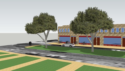
This is the Lawrence Group's rendering of the South Side Tower (formerly South Side National Bank) at completion. The picture is from Steve Patterson's recent post on Urban Review St. Louis.
You'd have immediately noticed the difference between the rendering and what was there prior to the rehabilitation.
But there's still something missing.
Pedestrian amenities!
Both Grand and Gravois are intimidating streets for a pedestrian to cross.
According to the measurement tool available at maps.live.com:
> Crossing Gravois on Grand, heading south from the White Castle is about 175 feet. This includes the triangular block in the middle.
> Crossing Grand on Gravois heading east from White Castle is about 130 feet, again including a triangle block.
Those distances are way too long.
Why not expand the sidewalk and rid of both triangles?
Why not place planted medians in the center of both boulevards?
I know the answer to these questions: because it would slow down traffic.
My response: exactly!
Planners are going to have to start advocating for the hard sell in St. Louis: inconveniencing motorists for the sake of pedestrians and cyclists.
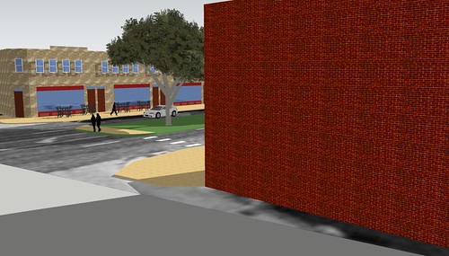
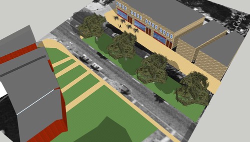
In the very crude mock up of the intersection below:
Medians are placed along both streets; these could continue nearly throughout each street's expanse, if funding called for it. Medians would help narrow the road and slow traffic, also making it more comfortable for pedestrians to cross. Trees within the medians would (eventually) shade the road and provide an attractive canopy. One traffic lane in each direction would be lost on Gravois and Grand. On-street parking would be allowed throughout. This one lane would be more narrow as well, allowing for a 4 foot bike path in each direction.
The orange triangles represent obliterated right turn opportunities. This helps slow down traffic too: the more the motorist must slow to make a sharp turn, the more aware of their surroundings they will be. In other words, these soft-angled turns inform the motorist that he or she should not have to slow down as much to complete a turn. Obviously, this arrangement is anti-pedestrian.
On the South Side Tower side, the disappearance of the triangle leaves ample room for a paved plaza with attractive lighting. This could be a spectacular patio for a restaurant that could claim the space inside the bank's impressive lobby (which is still not leased). If not, it could simply be the "front porch" of the development until a restaurant or other space found another use for it.
The ridding of the triangle islands sounds funny to us now. After all, who would want to dine on such large and noisy streets? Remember, though, that now there's a green median in the middle of the street, traffic is slower and not nearly as loud, and pedestrians feel safer crossing.
The black squares represent opportunities to seize a couple parking spaces from adjacent autocentric businesses to widen the sidewalks for this particularly pedestrian-heavy intersection. The erased island-triangles also provide more room for pedestrians.
These basic improvements would improve walking and biking conditions at this intersection 100 percent. And yes, this could not be relegated to one intersection. Both streets would need (and should receive) improvements throughout.
As long as planning in St. Louis (or the absence thereof) continues to do whatever it can to accommodate automobiles, we will forever be incentivizing big boxes and parking lots--not what we need to encourage more pedestrians, more eyes on the street, more local pedestrian-oriented businesses, and less crime.
Consider the new Kingshighway and I-64/Highway 40 intersection.
The Post-Dispatch posted a video of how it works (courtesy of MoDOT).
What a mess!
This set up is not designed for pedestrians at all!
I'm not even sure it's designed for cars.
You can tell that some traffic engineer drew this from a God's eye perspective and deemed it brilliant. On the street level, it's an absolute mess by the look of things.
Sure, now pedestrians won't have to deal with continuously merging traffic and will have a signal to walk with. They will, however, deal with a roadway given even more to the passing automobiles on the interstate. I just don't know if this was the best configuration.
And were there public meetings for this reconfiguration?
More on the I-64 mess later.
For now, we need to be redesigning our streets to benefit the pedestrians and cyclists we have for so long overlooked. Yes, this includes slowing down traffic and making driving less convenient. This will be the only way to encourage walking urbanism in the all-too-car-friendly city of St. Louis.
Tuesday, July 22, 2008
A plan to commemorate St. Louis's original street grid, including its French names. 10:51 PM
Afftonian and Francophile Thomas Mack wants to see signs put up downtown that reflect the city's founding French heritage.

While this quote is curious:
But [downtown Alderman Phyllis] Young raised a concern about the precedent Mack’s proposal might set. “The Hill might want to implement Italian names, and the Bosnian community might want to do honorary naming of streets in the Bevo area,” she wrote in her letter to Mack.
She totally misses the point that this is not about celebrating an ethnicity, but our founding heritage.
I say go for it! It's a smell step, but a smart one in recognizing that we have a history to be proud of.
One suggestion: a pole in a sleeker, black color looks more appealing than that construction-fence-gray.
Thursday, July 17, 2008
Forest Park Southeast to Receive Much Needed Streetscape/Infrastructure Improvements 2:01 AM
View Larger Map
No, I did not live inside the restaurant (the delectable Sweetie Pie's), but rather above it.
I loved living in the Grove, but coming home each day only reminded me of how much Manchester needs a makeover. Of course, as I've referred to in previous posts such as this one, I think many St. Louis streets could use the median treatment. It adds greenery, helps aid in pedestrian crossings, and beautifies a street. Of course, it requires maintenance.
That's why I was happy to hear about the creation of the Grove Community Improvement District (CID), recently approved by the Board of Alderman.
This is from the 17th Ward Website:
Neighborhood residents, business and property owners have joined together to form the Grove Community Improvement District (CID). The purpose of CID is to develop a comprehensive plan and budget to meet the needs of Manchester Avenue. After receiving feedback from various groups within the community, those involved in creating the CID aim to use funds to enhance security, plant trees and flowers along Manchester, repave and maintain new sidewalks, increase street cleaning, pursue marketing opportunities and coordinate economic development activities. The Grove Community Improvement District will allow Forest Park Southeast to compete with neighborhoods like the Central West End, South Grand and the University City Loop.
There's also an article about the CID here.
Streetscape improvements are long overdue for the Grove.
While you wait for new sidewalks and lighting on your way to Atomic Cowboy, check out the new Forest Park Southeast welcome sign/entry marker. Thanks to my good friend (and roommate at the Manchester apartment) Joe Decepida.
Monday, June 9, 2008
Tucker Boulevard should be, could be an urban street... 9:43 PM

That's the rendering for the new parking garage at Tucker and Clark. Even the announcement that the garage will feature LED lighting (changed periodically for sports and civic events) is simply not enough to distract from the simple fact that downtown needs no new parking provisions at all.
It should be clear enough by now that the more "convenient" (read: plentiful, cheap) parking is in an urban area, the less urban that area becomes. Visitors to and even residents of downtown may find it easier to drive everywhere and walk the least amount possible. All of the potential points between point A and point B are missed, leading to squandered opportunities for urbanism.
I saw the pared down plans for the Tucker facade of Park Pacific on Downtown St. Louis Business, and I am not impressed either. Another parking garage to front Tucker?
Already, the two bare minimalist high rises on Tucker just north of Chestnut and Pine are perhaps the most hideous high profile buildings anywhere--this coming from a supporter of mid-century modernism, mind you.
Tucker is so wide it appears to spar with Market Street for the title of preeminent downtown boulevard. It is tempting to say that the parking garage is better than the surface lot, but the surface lot is much more likely to be turned into offices, residential, clean industry, shops, or all of the above in the farther future.
We do not need two extra parking garages on this nearly (urbanistically speaking) dead street. It has the potential to be a real showcase street--a moniker New Orleans' similarly wide Canal Street is fighting valiantly to attain once more.
Thursday, April 3, 2008
No such thing as "aldermanic advocacy" 11:26 AM
What is "it"? The East-West Gateway's Great Streets Initiative, and specifically, the proposed streetscape improvements to Grand South Grand.
Shouldn't our leaders be advocates for better and safer design, for a pleasant streetscape that complements one of St. Louis's most bustling, exciting districts? Or could it be that the alderwoman is afraid that some residents will vote her out for slowing down their too-fast morning commutes on the superhighway that is the current South Grand?