Search This Blog (A.K.A. "I Dote On...")

Tuesday, December 22, 2009

Ghost Signs / Exploring St. Louis

St. Louis's urban blogosphere is getting so large it's hard to keep track of everyone's musings on the built environment of our fair city!

That's why I'm lucky to have discovered "Exploring St. Louis", one of the latest entries into the foray.

I think you'll really enjoy the author's post on St. Louis's numerous and storied "ghost signs". Don't forget to check out the accompanying Flickr photo set. And don't forget to bookmark!

Monday, December 21, 2009

New Life on Dolman Street

Back in August, the Zumwalt Corportation, located in Lafayette Square, sought the demolition of one heavily damaged unit in a trio of row houses on the 1600 block of Dolman Street near Lafayette. The company wished to renovate the remaining two houses while converting the site of the fallen row house to extra parking for their business. You can read the Cultural Resources Office (CRO) report here.

The Lafayette Square Restoration Committee, as well as the local historic district ordinance, does not take demolitions lightly. The apparent collapse on Preston Place just blocks away that I reported on earlier today was just that--a collapse, not a demolition--according to commenter Chris Yunker.

And so, the heavily damaged row house at 1624 Dolman Street did not receive approval for demolition by the Preservation Board during that meeting.

So many times on this blog I cover Preservation Board hearings and lament their outcomes. In this case, I was delighted to walk by the site this November and see it under renovation. The CRO staff report had said the owners found it financially infeasible to repair the structure; I'm glad to see they shored up the money!

To their credit, it was in a pretty pitiful state when the CRO photographed it this past August:


Here's my photograph, from late November:


Dolman Street was originally excluded from Lafayette Square's historic district boundaries. The detrimental effects of this arbitrary exclusion are clear today. Just a block over, on 18th Street, for the extent of the neighborhood, homes that are meticulously restored and maintained are the norm. Yet on Dolman Street, there are still many vacant properties and far too many vacant lots.

I lived in the 1000 block of Dolman Street in 2006. During my stay there, a derelict house across the street succumbed to a powerful storm and collapsed into the street. We had few neighbors as all adjacent homes had been long demolished. And our house even backed to the beautiful Harris Row. The alley between us might as well have been an interstate highway.

Luckily, the intervening years have brought stabilization of some of the properties and even plans for new construction. Case in point: tonight, the Preservation Board will review a proposal to construct a new home atop three vacant lots on the 1200 block of Dolman at the monthly meeting. The CRO staff recommended approval of the designs with some minor modifications. While it would be nice to see a higher density proposal, being able to witness Dolman Street fill up and rejuvenate is a personal pleasure for me.

Happy holidays!

Street Life in South St. Louis

Man selling Gus' Pretzels and roses on Cherokee Street at California.


So St. Louis. I miss Gus'.

Sunday, December 20, 2009

Demolition or Collapse in Lafayette Square?

While walking through Lafayette Square over Thanksgiving weekend, I happened upon this site, at 1724 Preston Place. Click here for a Bing Maps aerial view.


Per the aerial view on Bing, this looked to be a large two-family structure. Being located in the Lafayette Square Local Historic District (and very likely a contributing resource to the National Register District), I am surprised to see it in ruins. The neighborhood group, Lafayette Square Restoration Group, is usually strongly opposed to any demolition of historic and contributing structures. Furthermore, the matter never appeared before the Preservation Board to my memory.

Researching on Geo St. Louis, I find that it was issued an "emergency" demolition permit in July of this year. (An emergency permit would have automatically bypassed the Preservation Board's review). The photo above, showing the collapse or demolition, is from late November. Yet the emergency permit was canceled on December 2, 2009 and swapped for a regular demolition permit. Curiously, the original permit noted demolition of a "2-story, 2-family brick" structure while the new one says "2-story, 1-family brick". Could this have been a demolition of a rear structure, too, or is it just a typo?

Either way, the loss of this building is rather unfortunate. The host block was already halved by the construction of the bloated I-44/I-55 interchange. Now, the shortened block has a noticeably large hole in it. To be more optimistic I'd say the site is probably bound for some historicist new construction given the speed with which vacant lots in the neighborhood have been disappearing.

Still, if this is another case of the "emergency" demolition permit striking, it's clear that these requests should at least be reviewed by Cultural Resources Staff and should definitely be examined by a structural engineer except in the most egregious of cases, such as outright collapses. Even then, the remaining intact materials should be set aside for salvage by the ordinance.

Friday, December 18, 2009

Final December Preservation Board Agenda Now Online

You may access it here.

You might notice that two proposed demolitions in the Visitation Park Historic District have been removed. I am unsure as to why. See Vanishing St. Louis for more information on these buildings.

Sadly, the St. Louis Carnival Supply building at 3930 South Broadway, in Marine Villa, is still proposed for demolition. The intended use? Parking lot expansion for the adjacent strip mall.

I can't repeat enough how much St. Louis needs comprehensive, citywide urban design guidelines that ban the above types of requests outright. It's almost ludicrous to suggest that a couple extra parking spaces for a strip mall benefits the neighborhood--or the city--in even the most remote way. At the expense of a sound, urban building, it of course actually harms the city. More traffic, noise, pollution, curb cuts, lower property values, a loss of a potential investment opportunity, and a compromised pedestrian realm sums up what we "get" from such transactions. Read more about the history of the St. Louis Carnival Supply building(s) at Ecology of Absence.

Thursday, December 17, 2009

Buffalo, New York: Preservation by Neglect

Case in point from the last post. If you don't demolish historic buildings en masse, your city can eventually reap the benefits.

This take on the matter, from a USA Today article entitled "Buffalo charges ahead into the past", I found interesting:

Because there's no reason to tear down a building if there's nothing to replace it, Buffalo has benefited from "preservation by neglect." As Harvey Garrett, a neighborhood preservation activist here, sees it, "Buffalo was rich at just the right time" — 1870-1914, when great architecture was still relatively inexpensive — "and poor at just the right time" — after 1950, when many older buildings in cities with better economies were demolished.

While St. Louis was not "rich" in the modern period (1945-1975), federal monies were flowing in and the city was at its boldest and most progressive peak during this period. This does, of course, explain the part of St. Louis's culture that is so willing to part with old neighborhoods and housing. But countless cities, including ones often considered down-and-out like Buffalo, have done better by taking advantage of being more intact, having fewer interstates and other obstructions in their urban built environment.

My previous post was not meant to condemn St. Louis outright as a place with no hope to improve itself. My point is we have farther to go so we have to push even harder. The neighborhoods that remain preserved in St. Louis are outstanding, but those that are some of the most threatened today (Hyde Park, St. Louis Place) should be some of St. Louis's greatest. We can make this happen with sound urban planning and a refusal to accept mediocrity in urban design in the whole of our city.

Tuesday, December 15, 2009

Random Thoughts on the Cult of Destruction in St. Louis

In anticipation of a temporary move to Baltimore (more on that later), I was using Google Streetview to surf the city—extensively so.

After an hour or so of clicking and zooming and dropping the yellow Streetview man all over the city, several emotions came over me: shock, admiration, depression, and hope. 

Shock, primarily, because I cannot believe how intact the city of Baltimore is. I found a fairly large area on the northern periphery of downtown that seemed to have been cleared and replaced with a series of modern housing developments. Yet, for the most part, Baltimore’s signature (and unrelenting) row houses are e-v-e-r-y-w-h-e-r-e. The density and population capacity the city must have had at its height are simply astounding! Even knowing something of Baltimore’s history and architectural vernacular, I was still caught off guard. This was where the admiration came in; at the power of cities working at their best to produce a better quality of life simply by being cities. By being walkable. By having services located nearby. By offering opportunities for a tight-knit community to form. While Baltimore’s rows seem more monotonous than, say, St. Louis’s more architecturally diverse vintage 1880s streetscapes, even they offer a level of democratic individuality.

(I know I’m romanticizing a lot, but keep in mind I’m speaking of cities at their utmost ideal; the fulfillment of their potential).

The depression took me upon seeing whole blocks of these rows boarded, vacant. No cars, no trees, no pedestrians lining the streets. Just walls of row houses sitting vacant. I could “hear” the eerie silence even behind the computer screen, hundreds and hundreds of miles away. I got to thinking: how has Baltimore not torn out more of these rows and created park space or built new housing or just left them fallow, waiting for a time when investment would bring something new? Do whole abandoned blocks not cause issues with surrounding occupied blocks? Do they not pull the image of the city down? This, mind you, was my gut reaction, even as an avowed preservationist. Of course, I was happy to see them remain—thus the hope that later kicked in—but even I was wondering how they could have been spared the wrecking ball.

Then I remembered that I’m a St. Louisan; an automatic member of the cult of destruction. 

My leaders have, time and time again, supported the removal of a sturdy built environment and its replacement with something much less, something much worse. Often the replacement is meant to serve the purpose of moving or storing automobiles. This is the city’s greatest power because it is the simplest task at its disposal. Vacant buildings and lots provide convenient opportunities for combining narrow urban lots to form parking lots and garages. A 1920s-era bond issue already widened most roads to an extent likely even then excessive; certainly this was so by the time the region’s vast interstate network was introduced. So a declined city that wants to better move automobiles through itself need only maintain its roads and ensure every new development has ample parking.

The more and more I experience cities, the less and less I am willing to accept St. Louis's exceptional status as a destroyer of its most unique asset, its built environment.

Check out this recent thread on Skyscraper Page, but especially this 1950s-era photo of a recently-constructed Pruitt-Igoe complex at Jefferson and Cass:


You might see where this is going: I’m going to rail on the brand of urban renewal represented by Pruitt-Igoe. It’s out of scale, tore down a dozen blocks in the making, and apparently was not very well-built to serve the population it intended to serve. Sure.
 
But look around! Pruitt-Igoe’s decline certainly had a strong influence on its surroundings, but no one at the St. Louis Housing Authority held a gun to the city’s head and demanded they do this to the surrounding neighborhoods!  Of the hundreds and hundreds of structures shown in the photo, nearly all have been demolished, including the 33 11-story Pruitt-Igoe towers themselves.

Look to the south of the site (bottom and bottom-left in the photo). We see, in order, Cole, Carr, then Easton, today’s Martin Luther King Jr. Blvd. Row after row of cast iron storefronts—gone, no matter how irreplaceable they might have been! Look to the west (far left in the photo), today’s Jeff Vanderlou with apparently beautiful rows of mid- to late-19th Century houses, shops, and churches.

North (top and top right of the photo) shows the portion of St. Louis Place that’s now an “urban prairie”. This site was already tattered when plans circulated in the early 1990s to place a golf course and gated community on the site. Of course, since there was a plan, even an unfunded and ill-conceived one, the buildings came down. Now, naturally, Paul McKee, Jr., of the North Side development, is picking and choosing which of these structures represent “salvageable” “legacy properties”. In other words, we can reasonably expect yet more clearance of a good number of properties in this photo that have clung to life over decades of turbulent change.


New Orleans has endured decades of decline, like St. Louis, and, recently, one of the nation's worst natural disasters ever recorded, unlike St. Louis. It is said that 33 percent of New Orleans' structures are officially "blighted" circa 2009. Certainly blight in either city is formidable and a problem that needs to be addressed sensitively. The answer, however, is not to simply tear out buildings right as they become vacant. No New Orleans neighborhood--not even the most-storm damaged--is as empty as St. Louis Place. New Orleans did replace old neighborhoods with a series of low-rise public housing complexes, but their surroundings did not become the urban blank slates witnessed in St. Louis.


We must look to our peer cities and realize that our history and heritage, but moreover our urban built environment are our greatest assets. We need a comprehensive plan, backed by the force of law, to protect our remaining assets and to encourage the growth of new ones bound for their own protection oneday. We need to make sure we no longer take lightly the piecemeal (or wholesale) destruction of our built environment for something less or worse than what was there.


We need to recognize that our autocentric infrastructure not only destroyed neighborhoods upon its introduction. Our interstates and oversize roads continue to provide barriers to pedestrians and still lower adjacent property values and, of course, are still ugly and disrespectful of their urban context.


We need to be bold and comprehensive with regard to stabilizing and strengthening our built environment. Planners and designers of Pruitt-Igoe had the wrong idea--the superblock, the identical hulking towers, the clearance projects--but they had the optimism, the sense of direction, and the boldness and comprehensiveness nailed. Today's stock of leaders in our city are diffident, conservative, fearful or unwilling to change anything for the better.


We need new zoning and urban design guidelines to ensure that neighborhoods such as those pictured surrounding the Pruitt-Igoe complex can repopulate and spawn a new, bold identity. While Paul McKee has apparently stepped up to the plate to do so, this blog has communicated before its lack of faith in the city to assure something bold and truly beneficial to the area, aesthetically or socially speaking.


So when I use this blog to harp on a business needlessly taking down two buildings for outdoor dining, or a gas station in Hyde Park demolishing a vacant but beautiful historic commercial row for expansion, or yet another church ruthlessly ripping out mixed use buildings for a parking lot...I'm thinking of the photograph above. If only we had pro-urban rather than anti-urban planning! None of this would happen. There would not need to be so many individual battles; prospective parking lot pavers would encounter difficulties, roadblocks in making our city less walkable, less enjoyable, more ugly, less human. The photograph shows we have suffered too much, too long, too deeply.


We can solidify St. Louis as an urban environment. We must!


Sunday, December 13, 2009

This is St. Louis's Best Street

No, I don't have the answer. I'm only posing the question.

Imagine you had a famous urban planner coming in town who wished to get a sense of the city, but s/he only had time to traverse one street, with no deviations from that one street. You're selected as her/his guide. You'd be walking, so would not need to worry about street blockages like barriers and closures.

Which street in St. Louis would be the greatest for telling the story of our city? Ideally this would be a mostly positive experience, but St. Louis has and has had some pretty down moments, so it's expected that you'll run into some trouble spots. But remember the point is to find the most "impressive" street to guide a visitor along. I'll let you define impressive.

Which street do you choose?

Rules: For the road you choose, you must traverse its entire length. For the sake of keeping it interesting, the road must be at least 1 mile long. (Sorry, fans of Hemp Avenue in Forest Park Southeast)! If the street breaks or dog-legs, you are allowed to move around the obstacle and resume the course of the street so long as it retains the same name and is understood to be the same street. You are also allowed to "walk across" interstates.

Friday, December 11, 2009

St. Louis Infrastructure and Development Review

I've been lax on updating lately, despite the fact that St. Louis has seen some big news as of late. So why not crunch it all into one convenient post?

First, Highway 40's open again. Interstate 64. Whatever.

I'm flabbergasted by the largely positive response to the re-opening of the highway. It provided nothing for St. Louis but more highway lanes, fewer homes in Richmond Heights, a look fresh out of 1960s Brasilia, and better-designed interchanges. For hundreds of millions? Pardon my dripping sarcasm, but grrrreeeaaaaat. Call me out for not actually having driven the highway yet (not been home since it opened), but the pictures seem to me to only highlight the project's total lack of imagination.

Where's the lush median?

What about High Occupancy Vehicle (HOV) Lanes? These are pretty standard on many roadways. If you don't have at least one other person in the car with you, you cannot use the lane with a symbol like the one below:


HOV Lanes encourage (read: enforce) carpooling and therefore fewer smog-emitting cars on the road.

Better yet, as I've argued on this blog, why not simply end I-64/40 at McCausland/Clayton Road. At this point, there could either be an urban boulevard with a 35-40 MPH speed limit or...no roadway at all. The region survived a year or so without this segment of the interstate; it's hard to argue that it was vital to the survival of the region at this point. This would have been a great opportunity to open up Forest Park to the neighborhoods to the south and show that pedestrian traffic flow matters as much as automobiles. Oh well; another generation or two of an obtrusive interstate in a city that has far too many.

I know it's too late to complain (yet I persist), but I just am nauseated by the positive response to this large and wasteful infrastructure project when the region has so many greater needs for transportation infrastructure.

Next, the Archgrounds International Design Competition! Hearkening to the original international competition that netted Eero Saarinen's landmark Gateway Arch proposal, the National Park Service will hold another competition with an eye to reinvigorating the present grounds and forging connections with surrounding neighborhoods, including the East St. Louis riverfront. In keeping with my teeth-gnashing over Highway 40, I am absolutely thrilled that the project could see the removal of the depressed lanes of I-70 and even the elevated lanes at Laclede's Landing. This portion of the highway is set to become obsolete as I-70 is re-routed into Illinois over the new Mississippi River Bridge. Proposals must include removing this divisive eyesore from the equation if the Arch is ever to be psychologically connected to Laclede's Landing and downtown. I am beyond excited at these prospects!

Ballpark Village. I agree with blogger Rick Bonasch's (St. Louis Rising) sentiments on recent discussions of the Ballpark Village development. There's no "village" component being discussed at all! Not including residential in this high-profile parcel would be an enormous mistake, especially considering Blue Urban witnessed a nearly instant sell-out of the Ballpark Lofts development in a down economy.

The Bottle District. HRI, Inc. of New Orleans is set to redevelop the old McGuire Moving and Storage building into lofts geared toward artists. Excellent! It's great to see the Bottle District development start off on a positive, organic note. There are no contrived 700-foot skyscraper pipe dreams--just a sensible proposal to restore a historic building and inject new life into it.

Grand Center. Not to be outdone by downtown, Grand Center may soon be getting its own artist loft development in the old Metropolitan Building. Right now, this is coming to me in the form of an unsubstantiated claim on the Urban St. Louis forums, but hopefully we'll hear some sort of confirmation soon. This building was scheduled to become a hotel of the Hyatt brand, but those plans have fallen through.

As for hotels, Grand Center may soon have two. Again, Urban St. Louis forum rumormongers (a term of affection, mind you) stated that St. Louis University President Lawrence Biondi was opposed to a hotel proposal on Forest Park Avenue just south of campus, this one of the Holiday Inn chain. That one may still be going forward. But SLU is not sitting idly by. SLU is partnering with the Lawrence Group to transform the former Interiors Unlimited Building adjacent to Triumph Restaurant and the Moto Museum into a luxury hotel.

Could St. Louis be emerging from the recession?


Thursday, December 10, 2009

Favazza's Still Planning Two Demolitions on the Hill

While Favazza's restaurant on Southwest Avenue may have removed two demolition proposals from last month's  Preservation Board Agenda, their quest to rid of two adjacent commercial buildings is ongoing. (For some background, see this earlier post.)

The owners of the restaurant plan to demolish 5209 and 5211-13 Southwest for outdoor dining space. Right now, the plans to rid of 5211-13 (the farther west of the two structures) are only preliminary, while Favazza's is actively pursuing demolition of 5209 (the white building, pictured below).


Photo Source: Ecology of Absence

Here are the plans for 5209 Southwest:


I know Favazza has claimed that 5209 Southwest is too storm damaged to justify saving. I think, accepting that this is true, at minimum the facade should be saved. This would make for a unique outdoor dining concept.

Favazza has acknowledged 5211-13 is structurally sound and originally told me he had interesting plans for the site. Now it appears it will become outdoor dining, too, if things go their way.

I don't know what the next step is or if, somehow, Favazza has obtained a demolition permit for 5209 Southwest Avenue without going in front of the Preservation Board. The demolition item is not on the December agenda and so they may just be waiting a bit to have the space ready by springtime. Disappointing, indeed, to possibly face the loss of not one but two commercial buildings in one of St. Louis's most commercially successful and vibrant neighborhoods.

I would recommend calling Favazza's (314-772-4454) or emailing them (info@favazzas.com) to politely disagree with their plans to deurbanize the Hill.

Tuesday, December 8, 2009

December Preservation Board (Temporary) Agenda Online

You may access it here.

There are three proposed demolitions on the agenda. One item contains two proposed demolitions at 5305-07 Cabanne and 5309 Cabanne, both in the Visitation Park neighborhood.

Another contains a request to demolish a "3 story commercial brick/wood warehouse" with a concurrent request to rehab an adjacent structure (3924 and 3930 S. Broadway, in Marine Villa).


View Larger Map
Based on the information provided, it appears the building on the left (the Second Empire) would be saved and rehabbed while the "warehouse" (an old theater?) would be demolished.

More information as it's available.

Is the Tiffany Neighborhood Nothing Special, Architecturally Speaking?

Daniel J. Monti, author of "Race, Redevelopment, and the New Company Town" (1990) stated as much.

Here is the clip from Google Books:


Monti's work is about late urban renewal projects (circa 1970s) in St. Louis, including LaSalle Park and the Midtown Medical Center Redevelopment project, which ultimately saw many homes in the Tiffany neighborhood renovated.

This isn't news by any means: that an author would find the neighborhood's Foursquares with Victorian ornament ultimately unexciting. Still, I though it worthwhile to disagree. Even compared to more ornate neighborhoods, tree-lined Tiffany is, I feel, attractive. The author's sentence that is cut off at the end reads something to the effect of "Tiffany's housing stock was apparently classic enough, in its own democratic way, to qualify for inclusion on the National Register of Historic Places." The author clearly sounds unsure that Tiffany deserved this designation. He says basically the same of the "Ranken" neighborhood, a sliver of Forest Park Southeast whose central spine is Taylor Avenue.

Well, what do you think: is Tiffany anything special? Here's a Streetview capture of the 3600 block of Blaine Avenue.


View Larger Map

I find it very attractive and highly urban.

Monday, December 7, 2009

Want to See Where I Went While in St. Louis?

Check out my Skyscraper Page photos (and, if you're already registered, post a comment).

Part I: LaSalle Park

Part II: Soulard

Part III: Lafayette Square

Part IV:  Benton Park

Part V: Miscellany

Enjoy!

I promise more updates soon. Finals weeks, moving, etc. are getting in the way of regular posting.

Wednesday, December 2, 2009

We Love Cherokee (Yes, We Do)

Spotted in St. Louis (more on my return home later), an ad for Cherokee Street in the Riverfront Times.


Awesome! I checked out the website at the bottom--We Love Cherokee--and while it needs improvement in the functionality arena, it sure looks nice! Another confirmation that Cherokee Street is St. Louis's most promising, diverse, miscellaneous street/neighborhood.

Wednesday, November 25, 2009

The St. Louis Arsenal

Quick question: why is the St. Louis Arsenal, with several extant buildings dating to the 1830s and the very reason the state seized control of the Police Department in the 1860s, not a tourist attraction within a landscaped park overlooking the Mississippi River?

Answer: The site, located at Second and Arsenal Streets, is a parking lot.


The squat limestone and brick structures may not look that exciting, but the site is extremely historic and should have seen a more sensitive handling than being surrounded by a sea of cars. It's too bad AB-Inbev is tightening its belt; refurbishing the grounds of the St. Louis Arsenal would have been a great act of public philanthropy.

Here's a view of Building 12, constructed in 1834. The photograph was taken in 1975, from the National Register of Historic Places nomination :


I think we could work with this. The nearby Brewery Tours could lead people to the Arsenal Tour as an option. If Beer and Guns doesn't sell, nothing will.

Tuesday, November 24, 2009

Guess the Neighborhood, Revealed...

Good work to those who guessed the Gate District! (If you have no clue what I'm talking about, click here).

A couple of the photos are in the southern portion of the neighborhood, near or on Lafayette Avenue.

The point was to show off some of the Gate District's extant beauty. It gets a bad rap that I don't find wholly deserved. Sure it's got a couple blocks with almost completely new construction that is pretty disrespectful of what was once on the site, but there are plenty of gems and urban pockets that resist a complete "writing-off" of the neighborhood.

Good eyes, Gate District fans. Thanks to all who participated via the blog and Twitter. The most popular guesses seemed to be JeffVanderLou/St. Louis Place.

You May Now Purchase the Downtown Gift Card Online

In furtherance to a recent post, you can now click here, on the Downtown St. Louis Partnership's website, to purchase a gift card that applies only to one of more than 100 businesses located downtown.

What's the point? To keep holiday spending downtown! The holidays are a make-or-break point for retail stores, especially. This is why "Black Friday", the day after Thanksgiving, is so-named: it's the first day of the year that retailers jump out of the red and starting making a profit! With that in mind, please remember to patronize local businesses, who must compete against corporate stores often with longer hours and sometimes with lower prices. Our unique local businesses reflect St. Louis and no where else. A good local business will offer a better or different product from the national retailers and will hopefully provide you better service as well.

Now, the Downtown Gift Card applies to a couple chains/non-locals (Macy's is absent, notably), including most of the stores at Union Station. Still, purchasing this gift card allows you to introduce someone to downtown and, with any luck, one of its unique and independent businesses. You just might help a unique piece of St. Louis culture stay afloat! Bravo and good holiday cheer!

Monday, November 23, 2009

Guess the Neighborhood

A couple pictures...strategic information blocked out. Where are these pictures from? (Answer: the city's website, but no peeking now). No, seriously, which neighborhood would you guess hosts this architecture?


Have at it. Which of St. Louis's 79 neighborhoods do these pictures come from?(Yes, they're all from the same neighborhood).

Preservation Board Agenda Now Contains Only One Demolition

As reported on both Vanishing St. Louis and Ecology of Absence, three Old North St. Louis demolitions pursued by the LRA have been removed from the Preservation Board agenda, with one of them having been taken down a few hours ago. The active Old North St. Louis Restoration Group only supports demolitions when the front facade of the structure in question has been heavily damaged and is no longer recognizable as a historic building. The buildings on the agenda previously failed miserably to meet this demolition test. The neighborhood is lucky that they're off the agenda--and that they have such a great and progressive neighborhood organization.

That leaves only a Hyde Park demolition proposal, at 3959 North 11th Street. Luckily, the Cultural Resources Offices has recommended that the Preservation Board uphold staff denial of demolition of this fire-damaged building. The owners stated that they live in Texas and cannot afford to maintain the building at all much less repair it from its fire damage. Rightly, the Cultural Resources Office stated that the owners provided no proof of economic hardship and, furthermore, that Alderman Bosley (D-3rd Ward) is opposed to any demolitions within this sensitive district. Let us hope that the Preservation Boards heeds the decision of the CRO. Click here for the agenda item; the building is pictured below courtesy of Cultural Resources staff:


UPDATE (11/24/09): An UrbanSTL forumer has stated that this demolition has once again been denied. Good news!

The proposed demolitions on Southwest Avenue have also been shelved for now. As I mentioned in a previous post, the owner has told me that 5209 Southwest (the building closest to Favazza's restaurant itself) may still be subject to demolition at a later date. Its roof and rear portions are severely damaged from a storm a few years back. Favazza consulted with SPACE Architects, who reportedly recommended demolition of 5209 Southwest. The other structure, at 5211-13 Southwest, will be saved, Favazza informed me, and will be used once more. For what, I am unsure, but was told the plans were now in the works. If I get any more information, I'll be sure to let everyone know.

Sunday, November 22, 2009

What Would You Do to Improve the Morgan Ford Strip?

The unusually active folks behind the Morgan Ford Strip revitalization in Tower Grove South are soliciting ideas of events to hold on the street that will pull people to its growing repertoire of attractions.

Got any? Send them directly to the Strip via this Facebook link, or comment here.

I suggested a bike-in movie theater. For the cost of a projection screen and some creative signage, this would be a major neighborhood attraction that would get more people biking and walking. No cars allowed! (I yanked this idea from an awesome New Orleans Main Street Program street, O.C. Haley Boulevard in Central City. Great idea, guys!) I think it would work well on Morgan Ford. How about this spot below? I can't think of a better use of an otherwise unused parking lot at night.


View Larger Map

Project on the side of the commercial building; bike parking along the fence or at one of several cool bike racks on the Strip, and, voila, a neighborhood bike-in movie theater!

Saturday, November 21, 2009

Why Isn't the Hill in a Historic District?

I sent an email to Favazza's restaurant regarding their plans to demolish two structures on Southwest Avenue per the temporary Preservation Board agenda released earlier this month. I received the following response:

Thank you for your letter, the building at 5209 was struck by the tornado 2-3 years ago, it appears fine from the from but there is only half a roof, its full of mold, and is beyond repair (we had SPACE, a local architecture firm look at the building and they recommended tearing it down. We have decided to save the other building and have some plans in the works for it If you would like you can come by any time to see, view, talk or add input about the buildings thank you, Tony Favazza

According to this email, only 5209 Southwest (the white Romanesque structure closer to Favazza's actual restaurant) will see a demolition request now.

I then got to thinking: accepting that it's true that 5209 Southwest is beyond repair, why not save the facade and structurally sound exterior walls?

Then I remembered: there's not a single incentive or directive to do so. The Hill is not located in a historic district of any kind. In fact, almost none of Southwest City is. Yet the Hill seems like a no-brainer. Sure, some might argue that the Hill is full of tiny homes and shops that are technically no architectural wonders. You might also say that, even if they were at one time, so many of them have been badly altered over the years.

But the Hill is culturally significant as one of St. Louis's most preserved early immigrant neighborhoods. The Irish in the Kerry Patch north of downtown ultimately settled the Dogtown area, but even Dogtown fails to retain the level of "Irishness" that the Hill does for "Italian-ness". Soulard's early French Creoles were replaced mostly by Germans. Ditto for Carondelet, which gets little attention for either heritage.

The National Register of Historic Places has a set of criteria for listing, one of which is cultural significance. While I think the Hill could easily pass through on architectural significance alone, it would definitely get by on cultural significance. The Hill needs to be designated historic for several reasons. An obvious one would be to allow buildings such as 5209 Southwest to receive the state historic rehabilitation tax credit.

A local historic district--always more controversial than a federal listing due to more restrictions placed upon homeowners--may be necessary as well. A good economy brought the Hill more than a few "teardown" eyesores. The Hill's deep and narrow lots were subjected to completely out of scale new construction that call all the attention on these unassuming blocks to the new megastructure.

Google Streetview caught the construction of one such home on Daggett, just east of Macklind:


View Larger Map

The Hill is such a unique cultural treasure for St. Louis. Every time I visit, I feel as if I've stepped back into the 1940s, the decade from which some of the signage and just the general "happy small town" aura seem to derive from in my own mind. At the same time, it's quintessentially urban: highly walkable, mostly intact, visually interesting. It should remain that way. Hopefully, on Monday, the Preservation Board will recommend a creative solution to the structural problems of 5209 Southwest Avenue rather than outright demolition.

Again, if you'd like to voice your opinion on the matter, the Board meets Monday, November 23, 2009 at 4pm. The location is 1015 Locust, Suite 1200.

Thursday, November 19, 2009

Good Infill...Atop a Parking Lot? Am I Dreaming?

The Lawrence Group has released plans for Phase II of their South Side Station redevelopment. Phase I was the rehabilitation of the South Side National Bank building into residential units, saving the building from the Walgreens wrecking ball.

Phase II, the subject of this post, involves new construction on Grand at Tholozan (just south of Gravois). (Actually, the always-on-top-of-things Dutchtown West Neighborhood Association posted about this development on November 6, but this is the first time I've seen it or heard of it, so it's news to me).

Two things stand out. First, the proposed infill is, I think, quite nice. It's a clearly traditionally-styled building, yet not so much that anyone would assume the design was meant to fool you into thinking this is a turn-of-the-century work. The added density and massing should help make this section of Grand more aesthetically-pleasing and pedestrian-friendly, better matching the mostly intact Grand South Grand district to the north. Check the designs out for yourself.

The site plan:


The Grand elevation:

The Tholozan elevation:


Thanks again to Dutchtown West Neighborhood Association (DWNA) for running such an excellent and often-updated blog!

The second thing that stood out: this will subsume a large parking lot! In the same city where the San Luis Apartments, a fine structure worthy of rehabilitation, was recently torn down for a parking lot, it's great news to observe the reverse!

Make sure you bookmark DWNA's site for ongoing information about the western portion of the large Dutchtown neighborhood.

Finish Your Holiday Shopping in Mere Minutes: Downtown St. Louis Gift Cards

Downtown St. Louis is debuting "Downtown St. Louis Gift Cards" this Monday, November 23, 2009.

You may purchase one between the amounts of $5 and $500 and finish your holiday shopping in as long as it takes to order the gift card. The card will be accepted at at least 100 establishments downtown right out of the gate with more to come soon after. The card can only be used downtown and will keep money circulating downtown. This list of 100 includes restaurants, shops, and services all alike. See the bottom of this post for current participants.

If you're interested in a Downtown Gift Card, contact Matt Schindler at mschindler@downtownstl.org or 314-436-6500 ext. 223. It is unclear right now whether the cards will be available for purchase at some or all of the participating retailers and restaurants (or whether you'll have to order one directly from Mr. Schindler). I guess we will find out when the card debuts on November 23, 2009.

I think this idea is excellent. While it might be even better to include only downtown-specific businesses or non-chains, the effect could still be great. Imagine giving the downtown gift card to a relative of yours that has given up on downtown. Suggest that they take a stroll around UMA or Salt of the Earth, or buy some lunch at Flannery's. They just might be surprised at the progress of downtown--and might come back and spend more, with or without a card.

I applaud this effort of the Downtown St. Louis Partnership. It would be great to see a local business-specific gift card arise for St. Louis City and perhaps the County as well. Maybe next year...

Here are the presently participating businesses:

6 North Coffee Company
12th Street Animal Hospital & Boutique
12th Street Diner
American Institute of Architects (AIA) Store
Anthony’s
Baladas
Brewhouse
Beverly’s Hill
Boxers
Bridge & Tunnel Pizza (B&T)
Bubba Tea
Café Cioccolato
Capri Restaurant
Carmine's Steak House
Charlie Gitto's
Charm Boutique
City Gourmet
City Museum
Clark Street Grill
Culinaria - A Schnucks Market
Downtown Urgent Care
Edible Arrangements
Einstein's Bagels - St. Louis Union Station Marriott
El Borracho
Executive Salon
Flamingo Bowl
Flannery’s Irish Pub
Geechi's Florist
Gelateria Tavolini
Great Cuts
J. Buck’s
Jade
Kenary Park Florist & Gifts
Kitchen K
La Buena Salud
Lee J
Left Bank Books
Lombardo's Trattoria
Lucas Park Grille
Mama Figlia
MacroSun International
Mango
Marriott - St. Louis Union Station
McMurphy’s Grill
Mike Shannon’s Steaks & Seafood
Mosaic
Niche
Red
Renaissance Grand Hotel & Suites
Roberts Mayfair Hotel
Roberts Orpheum Theater
St. Louis Fitness Factory
Salt of the Earth
Starbucks - Hyatt Regency
Starbucks - Renaissance Hotel
Station Grille - St. Louis Union Station Marriott
Tony’s
Teutenberg’s
Washington Avenue Bistro
Westin Hotel
UMA
UPS Store
St. Louis Union Station
- Bud Shop
- The Candy Shop
- Cardinal Clubhouse
- Cardinal Rookie Clubhouse
- Charley's Steakery
- Culture Vibes
- Dog On It
- Edy's Grand Ice Cream
- Fat Sassy's
- The Fudgery
- Gateway News
- Gold & Diamonds
- Hard Rock Cafe
- Houlihan's
- Imani's
- Inspirations
- Key West Cafe
- Landry’s Seafood House
- The Lark
- Lids
- Marquess Gallery
- Missouri Threads
- Nestle Toll House Cookies
- Panda Express
- Photo Shop
- Pita King
- Play and Learn
- Quiznos
- Sbarro
- Shoes Etc.
- Sports Avenue
- St. Louis Jewelry
- St. Louis Taco & Grill
- St. Louis Union Station Parking (west or south lot)
- Subway
- Treasures
- Xtreme Game Play

More merchants still being added!

St. Louis Transit Ridership Grows at the 7th Fastest Rate in the Nation

Check out this graphic from Nate Berg's article "Transit Use is Growing, But Not Where You Think":


According to the article and graphic, the St. Louis region was the 7th fastest growing region for transit use from 2006 to 2008, showing a 16 percent increase in transit ridership between the two years.

Most comments about the reason for the jump in some seemingly unlikely cities (Charlotte, Detroit, Riverside, etc.) center around rising gas prices and a sinking national economy.

Transit use will continue to increase in St. Louis if the costs of driving increase. Another thing that will help decrease the rate of driving vs. transit is the growth of "road diet" streetscape improvement projects in the region and especially in the city. With Manchester and South Grand as the highest profile re-dos, these streets could demonstrate the importance of privileging pedestrians' safety and convenience over that of drivers. The usual saying "you can get anywhere in 15 minutes" should apply to hopping on a train or a bus and not so much to driving. Let's capitalize on the growth of transit ridership by continuing to cut subsidies to private automobile users.

Who says St. Louis never gets positive accolades?

Tuesday, November 17, 2009

Gate District Hodgepodge

The Gate District, while sometimes maligned by the urbanist set for its decidedly suburban new construction, has plenty of surprises befitting of the most urban of neighborhoods. I am not sure if I have ever witnessed a neighborhood so randomly interspersed with new homes, vacant lots, and historic ones as the Gate District.

Check out this block of Caroline Street in the Gate District.

From the scene below, and with more judicious cropping, one might assume the block is characterized by smallish classic red brick homes with some nice, if faded brick sidewalks to match.


The next lot to the west, though, is vacant and lacks any sidewalk.


Moving to the west just one more lot and we have one of those "suburban" intruders, with its tidy new concrete sidewalk.


In just three urban lots, we have urban, rural, and suburban settings. We have historic buildings, new construction, and no construction.

Say what you will about the Gate District, but it's full of interesting bits and pieces. If you're unfamiliar with the area, check out Floral Row, Diner's Delight, the SLU Medical Campus Urban Prairie, the Barr Block of historic Second Empire rowhouses, the Christian coffee shop in a rehabilitated circa 1867 Lutheran Church, the Theresa School, and much, much more.

I don't hear it referenced very often, but the Gate District is the product of the planning of superstar New Urbanist Andres Duany. Read more on that here.

Saturday, November 14, 2009

Conflicting Goals on Southwest Avenue

In the October 2009 Communicator Newsletter, the Southwest Garden Neighborhood detailed plans to re-do the streetscape along Vandeventer and Southwest Avenues.

Components of the project include upgrades to the pedestrian signals, crosswalk, and traffic signal timing at the intersection of Kingshighway and Vandeventer, implementation of a road diet along Vandeventer (reducing traffic lanes from 4 to 3, excep at the main intersections), installing new street lights with cut-off fixtures (which will reduce light pollution and increase lighting for the pedestrian), increased plantings of low maintenance ground cover and hardy tree species, reduced curb-cuts, and ADA-compliance.
Sounds great--and very necessary, right?

While I'm unsure of the boundaries of the project, it's nevertheless disheartening to see that a portion of Southwest Avenue may soon lose its urban charm and become less friendly to pedestrians even as another section of the road sees an upgrade.

Favazza's restaurant, located at 5201 Southwest, is seeking demolition permits for two neighborhood commercial/mixed use buildings, at 5209 and 5211-13 Southwest according to the latest preliminary Preservation Board Agenda.

These are the buildings in question:


View Larger Map


The full report is not yet online, so the reasons for the requested demolitions are not yet available (anyone want to call Favazza's and ask?). The best guess is, of course, a nice and spacious adjacent parking lot.

Unless the ultimate proposal is new construction on site, which I doubt, Favazza's plans to tear down two pedestrian-oriented buildings on a stretch of road soon to be improved just doesn't make sense. Again assuming a parking lot is coming, the result will be a less walkable, uglier street.

The Hill and adjacent Southwest Garden are thriving St. Louis neighborhoods. Especially in the case of the former, the record has shown that small, storefront retail with limited parking leads to a more walkable and walked neighborhood. The Hill's commercial rows are interesting--and lively for St. Louis, which is mostly starved of the brisk pedestrian traffic of denser cities in the Northeast.

Tearing down two buildings on a strip with major potential is an all around bad idea. Yet it's even less bearable when you consider the waste of public investment in making roads pedestrian friendly and then removing all the reasons pedestrians would ever want to walk them.

I think to Martin Luther King Blvd. from Jefferson to Grand as an example of a pure waste of money whose improvements only brought more attention to the sorry state of buildings along the stretch. The city and some private owners have worked together to strip most of the refurbished street and its sidewalks of any urban buildings that make walking interesting and comfortable, that give small business owners a chance to invite the pedestrians to the stretch in the first place. See what I mean?


View Larger Map
Here, new streetlights and sidewalks only cast light on the emptiness of the surrounding blocks.

My argument is not that disinvested places or streets with few urban buildings do not deserve to have better sidewalks; it's just that there should be a special effort to justify such investment. In other words, keep these roads as urban-formatted and pedestrian friendly as possible! Keep the remaining buildings in place; assign an urban design overlay zone that is very restrictive with regard to parking lots! Simple as that.

The Preservation Board should deny the ridiculous demolition proposals on Southwest Avenue. You may voice the same opinion at the monthly meeting, to be held:

Monday, November 23, 2009
4 p.m.
1015 Locust
Suite 1200

Please show up and protest bad, if typical land use planning in the City of St. Louis. See to it that our commercial corridors are ripe for reinvestment and pedestrians, not drivers and visual blight.

(My apologies in advance if Favazza's is experimenting with radically amazing new construction on site of these two fine buildings and is not, as I suspect, shooting for a parking lot).

Thursday, November 12, 2009

Southampton Neighborhood's Macklind Business District Gets Cool Metal Banners

Via the September 2009 Southampton Newsletter, these babies will soon be appearing on Macklind:


Great! I love to see such great evidence of St. Louis's unending neighborhood pride.

Tuesday, November 10, 2009

The History of Parking

The National Building Museum in Washington D.C. is playing host to a fascinating exhibit: the history of parking in the United States.

A Washington Post article on the exhibit pulls out a few interesting, if not altogether surprising points: parking lots used to be rare and parking structures were once given design consideration.

Yet the modern era that emphasized architectural honesty and a bold break from classicism admired the repetitive geometry of the concrete garage. It emboldened architects to highlight, rather than hide, increasingly large structures dedicated to that ultimate symbol of American progress and freedom--the automobile.

From the article:

There was an era, says Sarah Leavitt, curator of the National Building Museum show, when cities took pride in these structures. But that pride, based on the sense that a modern city couldn't progress without adequate parking, hid a darker indifference to the historical fabric of the city. The exhibition also includes before-and-after shots of a block of F Street NW, showing the loss of two historic buildings to a hideous parking garage built next to the Hotel Washington. It also includes an image of one of the most notorious parking garages in the world, the Michigan Theater in Detroit, made by slamming concrete decks into the shell of a classic and beautifully ornamented movie house. To this day, people still park there surrounded by the ghostly architectural shadow of a building once meant to please and delight.

In St. Louis, many of us are well aware of the history of parking. Parking garages--and other autocentric uses such as automobile showrooms--used to be housed in urban, street-fronting buildings. We saw this in the old Livery Stable on Locust in Automobile Row--demolished by SLU in 2007 for, ironically, a surface parking lot.


Livery Stable in the foreground. Photograph courtesy of VanishingSTL, which ran an excellent piece on the Livery Stable demolition here. Note how the Stable contributes to the urban streetscape; now it's a parking superblock.

The modern era in St. Louis was much as described above in the Washington Post article: architects boldly ripped out the historic built environment for oversized concrete garages. Of all the buildings that have been demolished in downtown St. Louis since the 1950s, parking garages are rarely among those targeted (if ever?). Some of downtown's dreariest and most life-sucking uses remain modern-era garages that must come down to create lively streetscapes.

Public Enemy Number One, in my opinion, is the outright hideous and, frankly, embarrassing presence of the Busch Stadium garages.


Who doesn't feel sorry for the pedestrian that has to walk a whole block beneath the hulking presence of one of the Busch Stadium garages? To think that they bookend the proposed Ballpark Village development, too! Clearly, in order to have an active "village-like" atmosphere, these horrific garages should go. Likewise, urbanists often lampoon Kiener Plaza for its supposed lifelessness; yet it's the hideous Kiener garages that flank the civic plaza that lend the space so much drear and droll.

In another urban planning and design disaster, the 1896 Century Building was destroyed to create a parking garage that mocked the original piece of architectural splendor. Detractors rightfully called it "Garage Mahal". This 2004 garage clearly retreated from the attention-grabbing antics of its modern predecessors (if for no other reason than the controversy over the Century demolition). Yet, somehow, its presence is only slightly more "welcoming" than Busch or Keiner.

No, by the way, street-level retail does not always mitigate parking garages ugliness. Something about the permeable nature of garages makes them uncomfortable for the pedestrian; they're open; the wind blows through, as if they were vacant, windowless buildings. Their concrete structures are usually heavy and foreboding; their nightime orange glow menacing.

The saga continues in St. Louis. Instead of getting Pyramid's "Mercantile Exchange" retail district with a restyled St. Louis Centre, we're now getting a parking garage with street level retail. While this deal may be preferable to a standalone, completely ugly and unadorned parking garage at the old Ambassador site as was originally proposed to placate downtown lawfirm Thompson Coburn--it's a far cry from good planning. Downtown has too much parking; each garage makes downtown a little less interesting and less walkable.

The history of parking in St. Louis, especially downtown, could have supplied the National Building Museum with plenty of material. Recall that the site of the Gateway Arch sat as a huge surface parking lot for decades (from the early 1940s all the way to the early 1960s), marring the riverfront and totally disrespecting the original site of the colonial city of St. Louis.

Despite lessons learned since then, St. Louis is still building parking garages for each new development, reducing their urban appeal. There's a recently completed garage at Tucker and Clark; look for new ones to rise with the Kiel Opera House redevelopment as well as the Municipal Courts Building. And those are all contiguous blocks.

As I've argued many times on this site, St. Louis needs a parking plan for its downtown and a zoning code that emphasizes the importance of pedestrian activity and safety over that of vehicular ease of access. With sound planning, the "future of parking" should be a much less lengthy story than its past.

Monday, November 9, 2009

Beautiful Block in Gravois Park


View Larger Map

While Gravois Park may be more known for its early 20th century, mostly preserved streetscapes, the eastern portion of the neighborhood closest to Jefferson retains some late 19th Century charm. The above block--3700 Texas--contains quite a varied and interesting collection of vernacular St. Louis architecture dating as far back as the 1860s, perhaps.

It has several Second Empire micromansions, some vernacular Creole cottages, some simple red-brick Italianate structures, and more. Scroll the block to check it out; it's a charmer.

Thursday, November 5, 2009

Would Bus Ridership Increase...

...if the bus stops looked like this?


Source: Planetizen, via The Design Blog

Instead of rusting in a junkyard, these decommissioned school busses contribute to the urban streetscape and busrider comfort.

Metro's Arts in Transit program's director should consider contacting the artist.

Speaking of Arts in Transit, the Poetry in Motion program seems intriguing. I'm assuming (it's not explained on the website) that these poems and the graphics that accompany them adorn the sides of busses and possibly Metrolink cars as well.

This poem, by Mary Ruth Donnelly, was my favorite:


Bringing art and life to transit will only endear people to it. Well done on both accounts.

Tuesday, November 3, 2009

Downtown St. Louis Needs a Parking Study

A parking study and plan for downtown St. Louis, backed by an ordinance that would adopt the findings and enforce them as law, could have prevented the demolition of the Ambassador Theater, the Century Building, and more.

A friend of mine from Providence, Rhode Island who now lives in St. Louis recently commented to me that he could not believe what downtown St. Louis had demolished for parking lots and garages, even since the 1990s. "Providence would have never done this," he said of the woefully misguided razing of the Title-Guaranty Building on the Gateway Mall. As many others have observed, vibrant cities hold onto human scale buildings and architectural diversity because they contribute to urban life. Supplying more spaces for cars creates convenience for drivers alone--not the route to urban revitalization.

A recent planning-related article I read put it simply: if you plan for cars, you'll get traffic; if you plan for people, you'll get people.

Without offering up a potshot at Culinaria--recently under fire for reportedly leading to the closure of several businesses downtown--the Century Building fiasco should have been the city's final wake-up call. Losing human scale, mixed-use buildings--or foregoing the opportunity to erect these buildings--should no longer be an option for downtown St. Louis. I'm confident that a parking study would reveal downtown is oversupplied. A complementary downtown parking plan could target city-owned garages for removal, or city-owned surface lots downtown (are there any?) that could be used for development.

A consulting firm well versed in urban planning and transportation planning would call for a ban on the construction of any parking-only building until the study was next updated (10 years?). We all know, and yet I feel compelled to repeat, that each parking lot and garage is an incentive to drive. For those that feel downtown parking is a pain and feel that parking garage rates are inflated given the oversupply of spaces downtown, it's an incentive to avoid downtown altogether. A sound parking plan would be, conversely, an incentive for public transportation ridership, for biking, and for walking. This translates to a more active, walkable, and walked city.

(See my St. Louis Beacon piece from last year for more thoughts on how parking-abundance hurts livable cities.)

Cary, North Carolina (outside of Raleigh) has a parking study that I stumbled across while doing research for work. While I've not delved into it too deeply, it intrigues me that a suburban community would look into determining parking deficit/surplus. When city government pledges to help each downtown law firm, etc. build its own adjacent parking garage, does it even ask this basic question?

Cary Parking Study Analysis

To see more of the Cary Study's documents, click here.

When will downtown St. Louis have a strategic parking plan? The answer is, almost assuredly, when "we" write it.

Wednesday, October 28, 2009

The St. Louis Mile: Longer Than 5,280 Feet?

There are several factors in what makes a place walkable.

Citing my own mix of experience in studying Jane Jacobs and urbanism, as well as being a pretty well-travelled pedestrian in both St. Louis and New Orleans, I would list the following on my "walkability" check list:
  • Manageable building heights, with any towers stepped back from the "base". Personally, for both walking and living, I prefer roomier and quainter residential districts and neighborhood-scale commercial areas to mid- and high-rise districts anyway.
  • The street should either be narrow enough to slow traffic, or have traffic slow enough to make me feel safe crossing right after a yellow light.
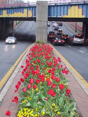
  • Of course, street trees serve multiple purposes for pedestrians: beautification, shade, rain barriers, buffer from cars, etc.
  • Seeing other people walking or having other visual interest and activity around makes walking less monotonous.
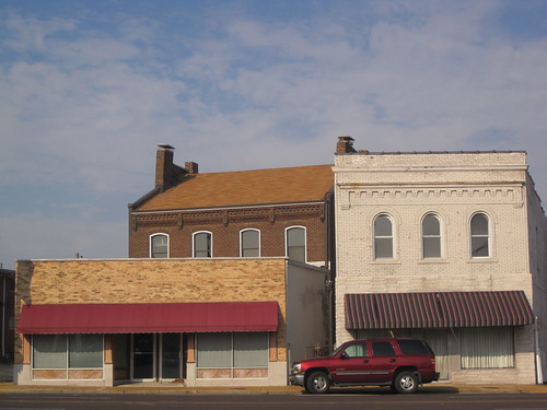
  • Building designs, from block to block, are hopefully varied and interesting as much as the activity on the street.

But the most important point is that there be a lot of corners. As a friend of mine here in New Orleans noted, corners are the lifeblood of urbanism. A plurality of them means more opportunities for neighborhood commerce and exchange, whether that's said in the literal sense (retail, restaurant, etc.) or the sense of community, wherein people "run into" one another and strike up conversations upon turning a corner.

Street corners force automobiles and other traffic to be more vigilant, especially the more of them there are and the more automobiles clamoring to get on one of the main roads. Almost no matter what, corners display the visual complexity of urban life. The best moment as a pedestrian (especially a leisurely pedestrian not in a time crunch) is to happen upon a busy corner and to be literally drawn in each direction to the point of having to halt in the middle of the sidewalk to decide if that corner over there merits a jaunt just to check things out.

In St. Louis, I think automatically to:


View Larger Map

Or perhaps less obviously:


View Larger Map

Either way, my "explorer" alarm goes off when I see such interesting things on all four corners (bonus points go to traffic circles that form super-intersections that remain pedestrian-friendly).


The reality is that St. Louis doesn't meet all of my requirements for full pedestrian comfort just yet. That's all right, as many areas are slowly getting there (Forest Park Southeast, Tower Grove South along Morgan Ford, etc.). Yet one problem with St. Louis's corner-making potential is that the blocks that feed into the mixed-use districts tend to be too long. In nearly all areas outside of St. Louis's old Creole street grid (Soulard, Old North, and Downtown), we have long "Victorian" blocks that were laid out with the notion of keeping activity (whether that activity is through pedestrians, streetcars, or vehicles) on shorter main roads with more corners.


To return to Maryland and Euclid in the Central West End:


The green line (North Euclid between Maryland and Pershing) is 477 feet.
The red line (Pershing Place between Kingshighway and Euclid) is 855 feet.


You'll notice that the "walkable" block (north-south) is Euclid, while the residential streets are nearly double the length and therefore less walkable. That means I have to amble twice as far to find the activity and vibrancy than if I were walking down Euclid (throw on top of this argument the fact that private or closed-off streets make a lot of pedestrians feel uncomfortable and unwelcome). Cherokee's situation is reversed in directionality, but is the same for all practical purposes. North-south streets are long, while intersecting east-west blocks with more commercial uses are short. It seems ingenious, and does contribute to walkable "strips" of activity.


But my contention is not that Cherokee, or Euclid, are not walkable streets. I feel that the city as a whole has committed the number one sin of walkability: making distances seem farther than they really are.


I've noted on this blog before the issue with long blocks (Jane Jacobs is not a fan, either). For drivers and for pedestrians, they offer fewer routes to get to the same place, thereby concentrating activity on the main drags. This is great for the driver of a vehicle who wants to, say, park on the northern end of Euclid (say, Delmar), get out of a car, and walk the strip down to Maryland Avenue. But for those who live technically within a sensible American walkable range (1/2 mile), their options for getting to Euclid and Maryland are probably insufficiently diverse as to ensure they walk every time if they still own a car. It doesn't help that it's often not very difficult to find a parking spot anywhere in St. Louis. That's a separate (albeit related) issue that I hear a lot of urbanists comment upon. I hear less about the perception of distance in St. Louis, which may be more related to long blocks than we think. A study is definitely needed.


To wit: when friends from St. Louis visit New Orleans, I usually forewarn them that when I say we're walking to a place that's "only 12 blocks away", it means we're roughly "six St. Louis blocks" from our destination. The number sounds scary to the inexperienced pedestrian, but the constant interest of the intersecting streets and their corners (not to mention the activity and the nearly universal human scale architecture) ease the pain a lot. For St. Louis, I fear a mile seems much beyond the traditional 5,280 feet metric in pedestrian psychology.


Maybe one reason folks don't talk about the problem of long blocks in St. Louis is that, well, it's an intractable one. Few people these days would argue we need to tear down houses in Tower Grove Heights to create new corners and through-ways (I wouldn't!). And pedestrian pathways, while nice features on overly long blocks, usually suffer from a look of privacy and, (as in the Northampton neighborhood's walk ways) and do not create corners in the traditional sense.


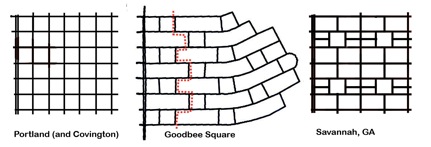
We could look to this interesting case out of the suburbs of New Orleans for some of our more tattered neighborhoods: the "Goodbee Square" in Covington, Louisiana. In this system, a grid is staggered to make north-south travel (in this case) inefficient for vehicles. While the article goes on to suggest that pedestrian paths should be created for such a system to make walking easier, a slight modification of such a grid could produce logical pedestrian paths, more corners, and at the same time make sure the new roads aren't used as cut-throughs exclusively. See below:


For intact neighborhoods, it's a matter of getting more people walking and returning corner mixed-use properties back to commercial life. Even if the grid itself can't be altered, a return to widespread commercial properties will still lend each block with a solid corner a degree of urban excitement, randomness, and possibility of discovery that St. Louis so needs.


It's a matter of public art, whether on sidewalks, in varied tree plantings, on the streets, fire hydrants, in gardens, even streetlights...St. Louis needs much more unexpected bursts of color and life.


Some neighborhoods, such as Forest Park Southeast, Downtown, and Old North, have various forms of themed walking trails. These are delineated by signs and markers. They make the unsuspecting pedestrian passer-by curious and might spawn further exploration. In other neighborhoods, removing concrete barriers and allowing vehicular traffic back through will strip these streets of their "semi-private" status and encourage more walkers. And I'm always an advocate of re-styling or removing altogether certain members of our much too intrusive interstate system, which creates wide psychological gaps as well (how far apart do Shaw and old McRee Town seem to you?).


The best way to reduce the St. Louis mile, if you're interested, is to walk anyway. Active streets are interesting streets. But it wouldn't hurt for you to create that interesting sidewalk art. Or plant that garden. Or plan the walking trail. Or lobby to patch up our tattered street grid. By then, hopefully walking will be so pleasant we won't even be thinking about how many more steps and blocks it is to that ultimate destination.

Fashion STL Style!

Fashion STL Style!
St. Louis Gives You the Shirt Off of Its Own Back!

Next American City

Next American City
Your Go-To Source for Urban Affairs

Join the StreetsBlog Network!

Join the StreetsBlog Network!
Your Source for Livable Streets

Trust in Rust!

Trust in Rust!
News from the Rustbelt

Dotage St. Louis -- Blogging the St. Louis Built Environment Since 2008

Topics: Historic Preservation, Politics and Government, Development, Architecture, Urban Planning, Urban Design, Local Business, Crime and Safety, Neighborhoods, and Anything Else Relating to Making St. Louis a Better City!